Tallapoosa · Railroad history
The Railroad Tallapoosa Sold Before It Was Built
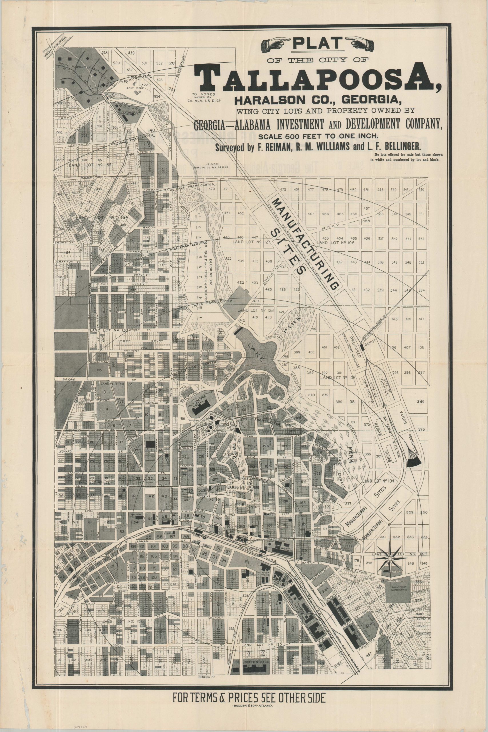
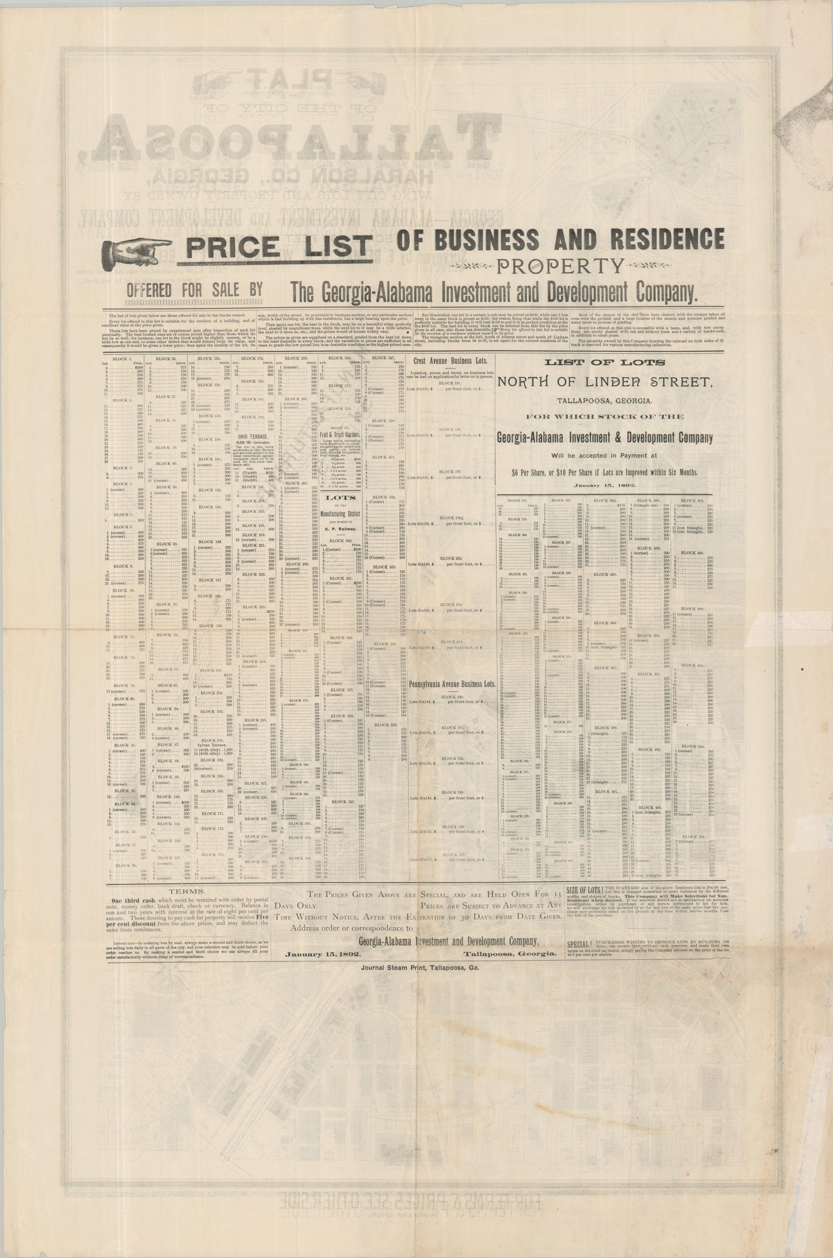
By 1892, a train could already take you from Atlanta to Tallapoosa, near the Alabama line. The company selling lots in town wanted buyers to picture a second railroad. Its sales map shows a roundhouse, yards and repair shops, all leading to grounds marked for a proposed Union Depot. A buyer could turn the map over, pick a lot and see what it would cost to live or do business near the new line. The railroad to Stevenson never opened. [1] [2]
In this story
The train that came
Tallapoosa already had a post office by 1849. Its old crossroads lay near today’s Broad Street and Arbacoochee Road. When the Georgia Pacific came through in 1882, the tracks passed about three-quarters of a mile south. A local correspondent reported that some residents had wanted the depot closer. [2] [3] [4]
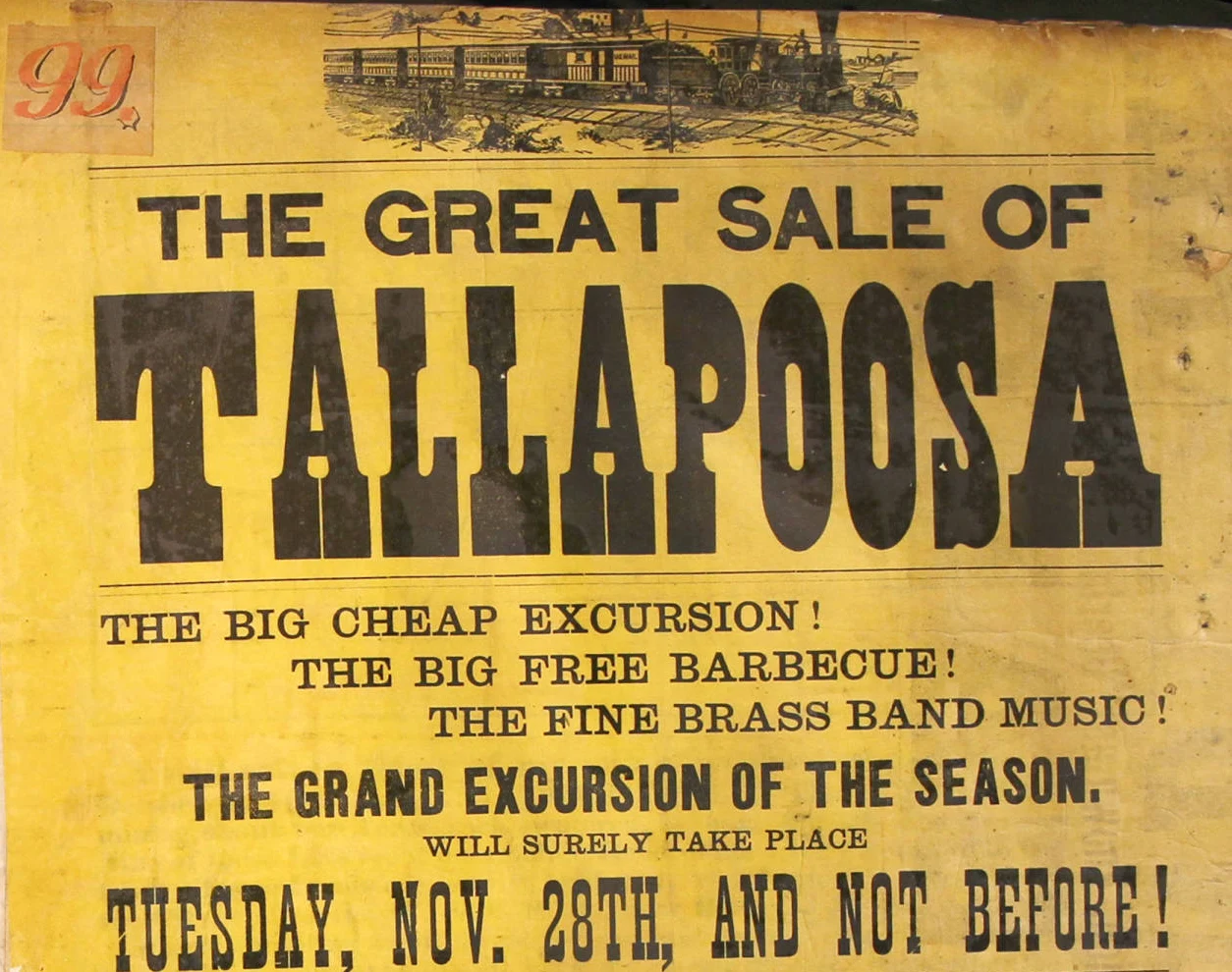
The depot gave merchants and land sellers a new place to do business. For his November 22 lot auction, Atlanta real estate agent George W. Adair advertised a $1.50 round trip by special train. Six days later, Thomas A. Frierson advertised his own train, free barbecue and a brass band. He urged buyers to wait for his sale of lots around the depot. [5] [6]
People could ride the Georgia Pacific and see where they might build a store or a house. Within a decade, promoters were asking people much farther away to invest in what could come next.
How far did the second line get?
In June 1892, the Haralson County Superior Court appointed a receiver to take charge of the development company. Five months later, The Engineering and Mining Journal reported that the route to Stevenson had been surveyed. An English engineer named Wheatcroft had gone over it with the locating engineer and hoped to bring in British capital. [2] [9]
Lyle Frederick Bellinger, one of the surveyors credited on the sales map, was also chief engineer for the proposed railroad, according to Norwich University’s history. That ties the map buyers saw to the engineers working out where the line might go. [1] [9] [10]
By the time the trade journal reported the survey, the development company was already in court-appointed hands. Engineers were still looking for money to build the line. The original survey and construction agreement remain to be located. [2] [9]
Stand beside the tracks that came
At East Atlanta Street and Head Avenue, look at how close the downtown buildings sit to the tracks. That’s the part of the story you can see from the sidewalk. Then open the sales map and follow the second line to its proposed depot. The railroad that came changed where Tallapoosa built and traded. The one on paper shows how much more the promoters thought they could build, and how far away they went looking for people to pay for it. [1] [2]
Explore the original records
Open these records at the archive or family website for a closer look.
- Read the price list on the back
The terms and the January 15, 1892 date appear below the numbered lots.
- Read the Kansas stock advertisement
Look in the center-right of the page for the Tallapoosa offer.
Sources and research notes
The reason the Georgia Pacific chose its precise route south of Old Town is still open. The original survey, construction contract and funding records for the later line remain to be located. The trade journal spells the locating engineer’s surname Ballinger. The shared initials and work on the same railroad point to Bellinger.
- Tallapoosa sales circular, January 15, 1892
The map face names the surveyors and shows proposed facilities. The dated reverse states prices and payment terms. - North Tallapoosa Residential Historic District nomination
Section 8 covers the old crossroads, Georgia Pacific arrival, promotion of the second line and the June 1892 receivership. - George White, Statistics of the State of Georgia, 1849
Printed page 147 lists Tallapoosa among Carroll County’s post offices. - November 4, 1882 Tallapoosa dispatch, Weekly Constitution
Printed page 6, first column. The dispatch reports that some residents wanted the depot nearer. - Adair’s November 22, 1882 auction poster
Tallapoosa broadside at right. Kenan Research Center, VIS 347.002.095. - Frierson’s November 28, 1882 auction poster
Tallapoosa broadside at right. Kenan Research Center, VIS 347.002.099. - Chase County Courant, February 5, 1891
Original stock advertisement. Investment projections in the advertisement are the seller’s claims. - Weekly Heppner Gazette, February 19, 1891
The Oregon front page carried a similar offer. - Engineering and Mining Journal, November 26, 1892
Printed page 518 reports the survey and Wheatcroft’s trip over the proposed route. - William Arba Ellis, Norwich University, volume 3
Pages 73–74 identify Bellinger and describe his work in Tallapoosa.


Read another local story
 Tallapoosa’s hotel above the quiet springsRemastered from a print supplied by Jackie Jones’s family. Colors and fine details interpreted; original artist/date unconfirmed.
- Bremen hiding in plain sight
What story should we tell next?
Is there a person, place or piece of local history you’d like to see on Moss & Sons? Perhaps your family has photographs, letters, an old business record—or a memory you’d like to share.
You don’t need to have the whole story. Tell us what you know, and we can start there. Daniel reviews contributions and confirms permission before anything is published.
Know someone who would enjoy this? Pass it along.