Atlanta airport · The Flint River headwaters
The river beneath the runways
Before you follow another departure sign, try following the water.
In this story
A river can begin very quietly
The Flint does not begin as the broad river a traveler might picture. Near Atlanta’s airport, groundwater gathers into small headwater streams, and part of that water passes through concrete beneath the runways. The New Georgia Encyclopedia describes a visible beginning near Virginia Avenue in Hapeville, followed by the water’s disappearance into a culvert. [1]
Downstream, Sullivan, Mud and Camp creeks add their water. The Flint crosses from Georgia’s Piedmont into the Coastal Plain and eventually meets the Chattahoochee at Lake Seminole. The river leaving that lake is the Apalachicola, flowing through Florida toward the Gulf. The airport belongs to a much longer water story than its fences suggest. [1]
How the water went underground
Finding the Flint’s historical maps show the change in stages. The 1909 automobile speedway occupied comparatively level ground beside the headwaters. A 1927 image still shows streams around Candler Field. During the 1940s, runway extensions carried the airport across the Flint, and sections of the headwaters were straightened and buried. [2]
Longer stretches entered culverts during construction of the Midfield terminal in the 1970s. Expansion also displaced residents who had grown up near the streams. Another change came during fifth-runway construction in 2004: Sullivan Creek was piped, and more of the Flint became enclosed by airport fencing. These were successive decisions about moving aircraft, water and people through the same ground. [2]
Read those maps slowly and the familiar airport changes shape. A runway plan emphasizes clear space and connections. A watershed map asks where rain goes and what lies downhill. Neither map alone tells the whole story.
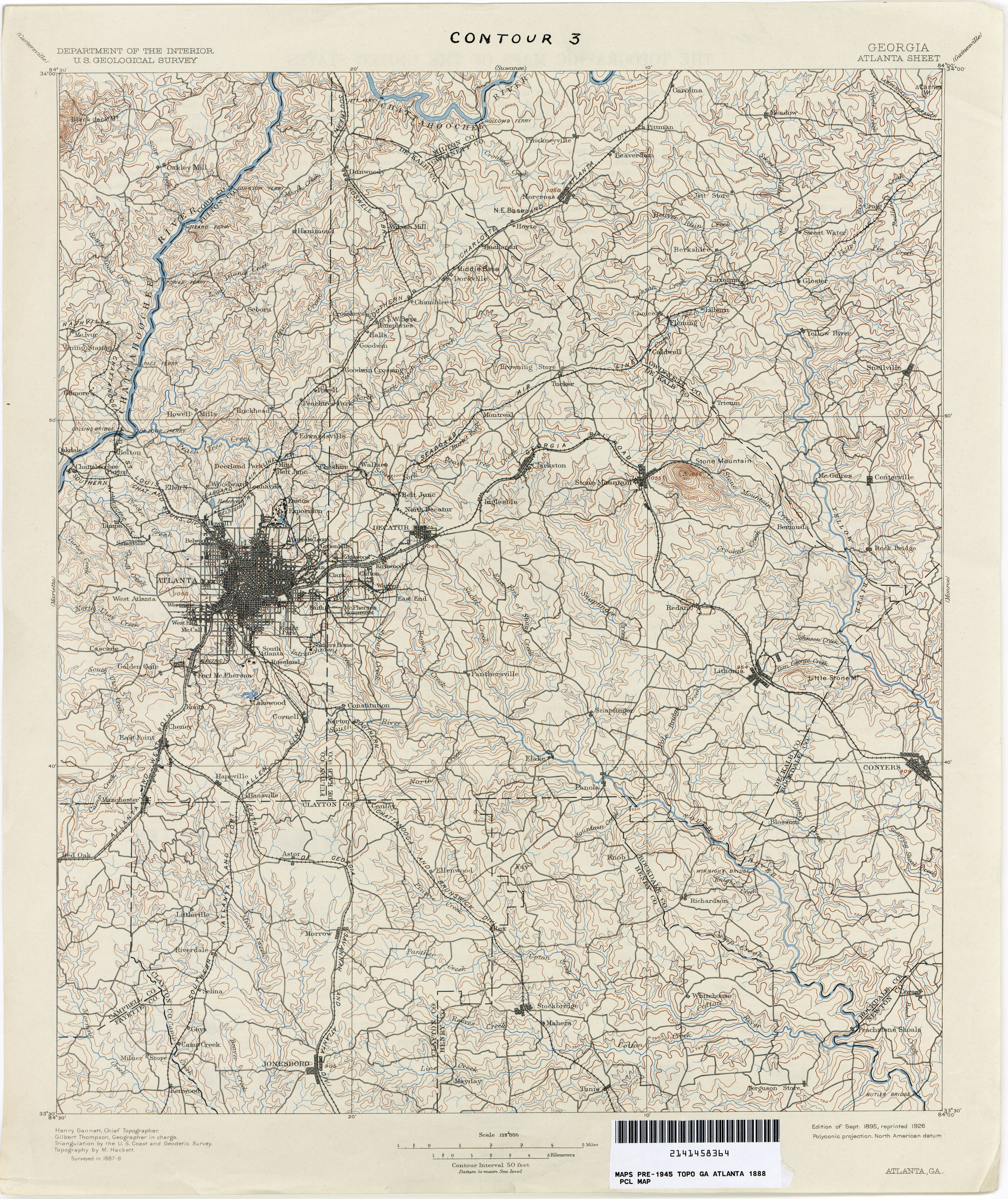
U.S. Geological Survey · Perry-Castañeda Library Map Collection, University of Texas at Austin. Public domain in the United States.Enlarge this recordMap collection and dates
What pavement changes
A pipe keeps water moving, but it cannot replace everything a watershed does. American Rivers’ 2014 Upper Flint action plan explains why roofs and pavement matter: rain that runs quickly off a hard surface has less opportunity to soak into the ground. Groundwater ordinarily feeds streams between storms. Hydrologists call that slower contribution baseflow. [3]
The distinction helps explain how a developed watershed can face both rapid runoff and weak flow during dry weather. The plan recommends restoring infiltration where appropriate, protecting land and improving water management. It does not promise that one rain garden—or opening one buried stream—can restore the entire river. Water withdrawals, reservoir operations and other changes also affect its resilience. This is a basin-wide problem with many people sharing the consequences. [3]
The life farther downstream
American Rivers describes the Flint’s shoals as habitat for fish including shoal bass and the Halloween darter, with shoals spider lilies among the river’s distinctive plants. Its conservation history includes resistance to the proposed dam at Sprewell Bluff, supported by then-governor Jimmy Carter. Those rocky reaches help explain why people care about water that begins so inconspicuously near Atlanta. [4]
The Conservation Fund connects the hidden headwaters to drinking water, wildlife habitat and recreation downstream. Its restoration work looks at both the airport-area streams and the wider Upper Flint watershed. That is a useful correction to thinking of a culvert as merely a drainage fixture: the water leaving it is still part of a river other communities depend on. [5]
There are two journeys here. A passenger may leave Georgia within an hour of takeoff. Water follows the landscape, receiving more tributaries and carrying the effects of choices made upstream. That connection remains even when the first part of the river is difficult to see.
Putting the river back into view
Finding the Flint grew from work by American Rivers, The Conservation Fund and the Atlanta Regional Commission. Its account describes a 2015 airport partnership studying stormwater and green infrastructure, followed by a wider headwaters vision in 2017 with urban designer Ryan Gravel’s firm and author Hannah Palmer. The work links ecological repair with the communities living around the airport. [6]
Parks, trails and restoration appear in that vision. They are reasons to follow the project, not evidence that every line on a concept map is an open public path. The Conservation Fund describes a continuing effort to create access and protect land. This story is something to read at your gate; airport culverts, fenced streams and service roads are not suggested walking destinations. [5]
For a closer look from your seat, open Finding the Flint’s historical map sequence in the sources below. Compare the early airfield with the later runway works. The water is a small feature on some of those maps, but following it reveals how much else changed around it. [2]
Sources and further reading
Sources reviewed October 25, 2026. This account distinguishes a visible headwater outlet from the larger drainage feeding it. Published river-length and undammed-distance figures vary; no single mileage is asserted here. Historical plans are not evidence of current public access or completed restoration.
- Susan D. Morris, New Georgia Encyclopedia: Flint River
River geography and tributaries. Its older policy and visitor information is not treated as current guidance. - Finding the Flint: historical maps and photographs
The project’s illustrated account of successive airport expansions. Open the sequence to compare the landscape over time. - American Rivers: Upper Flint River Resiliency Action Plan (2014, PDF)
Especially printed pages 5–10 on altered flows, the source watershed and proposed restoration. - American Rivers: Flint River
Ecology and conservation history, presented from a river-conservation organization’s perspective. - The Conservation Fund: Finding the Flint River
Downstream connections and the organization’s restoration and access goals. - Finding the Flint: how the project began
Participating organizations, the airport partnership and the 2017 headwaters vision.
Read another local story
- Who were Hartsfield and Jackson?About 5 min read
- The working town beside the airportAbout 5 min read
- Bored at Atlanta Airport? Explore Before You Board
Share a photo, memory or landmark
Daniel reviews contributions before anything appears publicly.
Know someone who would enjoy this? Pass it along.