Native history · Everyday life
When the Tallapoosa Was Home
Picture a morning beside a river in Creek country. Smoke rises from a cooking fire. Someone takes corn from storage. Beyond the houses lie cultivated fields; beyond those, woods where people know the hunting grounds and the food-bearing trees. A household’s day will depend on all three places: the field, the forest, and the water. [7][9]
For many Native communities in the country that became West Georgia and eastern Alabama, home was an established town with fields and a surrounding territory. Farming supplied a major part of their food. Hunting, fishing, and gathering completed the system. People traveled with the seasons, but they also had crops to tend and a harvest to bring home. [5]
Even the Plains comparison needs a little care. Some Plains nations followed bison extensively, while the Mandan, Hidatsa, and Arikara combined village agriculture with hunting. Native America contained many different ways of making a living. [2]
Here, the story changes with the century. Native people lived in the region long before the Creek confederacy took shape. Earlier Mississippian societies built substantial settlements and mound centers. The later confederacy brought together communities with different languages and histories. By the 1700s, its river towns belonged to an extensive, interconnected Native country. [1]
Start close to home. The Tallapoosa begins in Paulding County, and the Little Tallapoosa begins in Carroll County. Both cross into Alabama. These waters make West Georgia part of a landscape much larger than any modern county. A small upstream creek belongs to the same drainage system as the larger river farther west, even though the settlements along it may have differed greatly. [3]
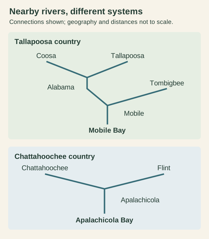
The Coosa offers another connection: it begins where the Etowah and Oostanaula meet at Rome. The Tallapoosa and Coosa belong to the Mobile drainage, while the Chattahoochee belongs to the separate Apalachicola system. Those distinctions matter when telling a local river story; nearby waterways do not all run into one another. [4]
Historically, the English labels “Upper Creek” and “Lower Creek” distinguished broad groups of towns. Upper Creek country included the Coosa and Tallapoosa; Lower Creek communities were associated especially with the Chattahoochee. These were parts of a diverse confederacy whose towns retained their own identities. [5]
A particularly useful place to enter that country is Newyaucau, also known in later writing as Nuyaka, on the Tallapoosa in present-day Alabama. The National Park Service places it near Horseshoe Bend and connects its inhabitants with an earlier Chattahoochee settlement in what is now Heard County, Georgia. That is a direct West Georgia connection: people carrying their town life from one river valley to another. [18]
Writing in 1798–1799, federal Indian agent Benjamin Hawkins described Newyaucau on a river flat, with stony, rolling country nearby. Pine, oak, and hickory grew around it. At the upper end of town was a ford. Some inhabitants had established themselves on good land beside Inn-nook-fau Creek. These details put the river to work in the story: cultivable ground, a crossing, and a tributary that offered room for households to spread out. [19]
Farther downstream, Hawkins described Tuckabatchee beside the Tallapoosa, with two crossings usable in summer and formerly cultivated islands upstream. Seasonal water levels mattered to movement; usable ground mattered to food. His record offers a view of a river people knew in practical detail. It must also be read critically: Hawkins promoted federal efforts to alter Creek settlement and work, and his judgments reflect that agenda. [19]
At Newyaucau, archaeology supplies a different kind of evidence. The National Park Service reports household features, pottery, and a storage pit later used for refuse. Researchers interpreted the ceramic evidence as belonging to a settled, family-based community. The things left in the ground help bring the town into focus as a place where people kept house. [18]
To picture a household, think of several useful buildings around a shared space. Historical descriptions include timber-framed houses with plastered walls, separate summer and winter accommodations, and a building for storing grain. The arrangement varied with the household. A home had to accommodate cooking, heat, cold, and the protection of food that might be needed months after harvest. [7]
Family relationships shaped this world. Muscogee clan identity follows the mother's line, a heritage Muscogee people continue to explain and honor today. In a 2026 Mvskoke Media account of an exhibition about women, the objects included a corn-pounding stone and a sofkee spoon. Food preparation belongs in the history of family knowledge as well as in the history of farming. [12]
The fields held corn, beans, and squash, including pumpkins. At Cusseta on the Chattahoochee, a Creek Heritage Trail marker describes crops grown together, communal fields, and gardens near houses. Women did much of the planting, harvesting, and preparation. Feeding the town required knowledge of soil, seed, timing, and storage, followed by the daily work of turning harvested crops into something people could eat. [8]
Harvest did not mean eating everything while it was fresh. Families stored produce from their plots, and communal stores could help supply visitors or households whose provisions ran short. A good growing season had to reach beyond the growing season. Seen this way, a granary was as important to the household as a hunting weapon: it carried work already done into the months ahead. [7]
The year brought different demands. Spring planting and autumn harvesting anchored activity around the towns; winter hunting could take people away for extended periods. Settled life and seasonal travel belonged together. Nor did a town necessarily remain on one patch of ground forever: worn soils, reduced wood supplies, and pressure on game could contribute to relocation. [6]
Corn also helped order community life. The Green Corn ceremony was a major occasion for renewal and reconciliation, with customs that went well beyond the harvest itself. Food production was connected to relationships and responsibilities within the town. [5]
Outside the fields, the foods become familiar to a West Georgia reader. Archaeological evidence from the upper Piedmont, reaching back into the Late Mississippian period, includes hickory nuts, grapes, and persimmons, alongside deer, turkey, rabbit, squirrel, fish, and freshwater mussels. Cultivated food existed within a larger food landscape. The woods beside a settlement offered resources that changed with the season. [9]
Hickory nuts deserve more attention than they usually receive. The Cusseta interpretation describes storing them and extracting oil for cooking and seasoning. A nut gathered from the ground could contribute something quite different from a handful of kernels. Collecting food was only the beginning; processing it made it useful. [8]
Corn required that same skill. Archaeologist Tanya Peres describes Muscogee cooks softening kernels with hardwood ash and water before rinsing and cooking them. She also discusses additions such as hickory nuts or their oil. The familiar name sofkee, also spelled sofke or sofky, refers to a corn preparation often described as a drink, soup, or thin porridge. It belongs to a continuing food tradition with variations in preparation. [20][21]
The work behind a bowl of corn is especially clear in historian Devon Mihesuah’s study of foodways after removal to Indian Territory. She describes pounding, sifting, and cooking, and documents Muscogee corn preparation in historical photographs. These later records cannot supply every detail of an earlier Tallapoosa kitchen, but they show how much labor and knowledge a food name can conceal. [21]
Fishing involved more than waiting beside the bank. Across the Southeast, people used nets, hooks, spears, baskets, and weirs. Some inland weirs formed a V that guided fish toward a narrow capture point. The river’s movement became part of the equipment. Such structures help explain how people could harvest fish through knowledge of a channel and its current. [10]
The river connected people as well as feeding them. Trails and waterways linked Creek towns and clans: relatives elsewhere, a neighboring community, people arriving with news or goods. Travel over land and travel by water belonged to the same network. A river could be a route on one journey and a crossing on another. [11]
By the eighteenth century, that world also reached overseas through trade. Deerskins moved out, while cloth, metal kettles, firearms, and other goods moved into Creek towns. Hunting could serve commerce as well as the household. The contents of a home changed as families acquired new tools and worked them into familiar tasks. [1]
Food changed, too. Excavation evidence from a historic Creek town included pig, cattle, and chicken remains and peach pits alongside indigenous foods. By this period, introduced plants and livestock could be part of Native households. Cornfields and peach trees could exist in the same community, with histories of different lengths behind them. [16]
The losses that followed were losses of these lived-in places. Land cessions stripped away Creek territory, and U.S. forces drove many Muscogee people west in the 1830s. Removal uprooted households, fields, and relationships with particular rivers. It was not simply a population choosing to take up a different residence. [1]
But the people and their knowledge continued. The Mvskoke Food Sovereignty Initiative's Traditional Mvskoke Foods Recovery Project worked with growers and elders to recover access to sofke corn and Indian pumpkin seed. Its account traces those crops to southeastern homelands and describes the importance of family growing histories. A seed can preserve a connection that a boundary on a map cannot show. [13]
That work is still happening. In October 2026, Mvskoke Media reported that educators and students at the College of the Muscogee Nation shared heirloom pumpkins and corn through a program intended to expand seed supplies and encourage community growing. The farming story continues in living households and gardens. [14]
The next time you stand beside the Tallapoosa, try looking at the landscape with those ordinary needs in mind. Where could a household grow food? Where would it store the harvest? Which trees would matter in autumn? What could the river provide, and how would people reach their neighbors? Those questions bring the past closer without pretending we know the name of every person who lived beside the water.
How this story was researched
The main historical setting is Creek country in the 1700s and early 1800s. Earlier archaeological findings and later Oklahoma food traditions are identified where they appear. Regional evidence does not establish a village on any particular West Georgia property, a fixed household menu, or the origin of an unstudied stone feature in a creek. The discussion of fish weirs describes a regional practice, not a verified structure at Newyaucau.
Hawkins supplies contemporary observations, while archaeology, later scholarship, and Muscogee reporting supply other perspectives. No dialogue or named historical character has been invented.
Sources & reading notes
Numbered links in the story lead to these sources. Notes identify scope and limits.
- Muscogee (Creek) Indians
Historical development, trade, land loss, and forced removal. - Subsistence: Tribal Nutrition & Health
Plains farming societies; used only for the comparison. - Tallapoosa River Basin Management Plan
Headwaters and watershed geography. - River Basins
Coosa, Etowah, Tallapoosa, and Chattahoochee drainage relationships. - Creeks in Alabama
Confederacy, river regions, farming, and ceremonial calendar. - Upper Creek Towns of the Historic Period
Named Tallapoosa towns and seasonal activity. - Creek Indians
Household buildings, fields, and stored harvests. - Creek Agriculture
Cusseta evidence for crops, women's work, sofkee, and hickory use. Marker co-sponsored by the Muscogee (Creek) Nation; not a survey of the upper Tallapoosa. - Southeast Chronicles: Kennesaw Mountain National Battlefield Park
Regional archaeological evidence, particularly Late Mississippian foods; not a specific Haralson County village menu. - Fish Weirs as Part of the Cultural Landscape
Fishing technology and the limits of archaeological identification. - Creeks organize to resist white expansion
Connections among towns through trails, rivers, and kinship. - Matriarchal legacy featured at Mvskoke Waters Gallery
Muscogee perspectives on matrilineal identity and food traditions. - Traditional Mvskoke Foods Recovery Project
Traditional seed lines, elders' knowledge, and crop recovery. - Oh My Gourd!
Current work by College of the Muscogee Nation Extension. - Etowah Indian Mounds State Historic Site
Public interpretation of an earlier Mississippian river community. - The Battle of Horseshoe Bend: Collision of Cultures
Historic Creek life and archaeological evidence of introduced foods. - Horseshoe Bend visitor information
Museum interpretation of Muscogee life and the 1814 battle. - Horseshoe Bend National Military Park Cultural Landscape Report
Printed pages 12–13: Newyaucau's Chattahoochee connection, settlement, and archaeological evidence. - A Sketch of the Creek Country in the Years 1798 and 1799
Printed pages 27–29 and 45–46: Tuckabatchee and Newyaucau. A federal agent's account with an assimilation agenda; place-name spellings vary. The online transcription contains OCR errors. - Feast or Famine Corn’s Role in America’s Prehistory
Archaeologist's discussion of Muscogee corn preparation. - Sustenance and Health among the Five Tribes in Indian Territory Postremoval to Statehood
Pages 270–272 address corn processing and sofky. The Oklahoma setting and later dates are kept explicit.
Read another local story
 The Lake Haralson County Never GotUSGS · 1975 aerial photograph
- The old ridges across a hillside
 Biscuits, pies and the people who fed West GeorgiaPublic domain. Published in New York in 1898; Library of Congress explicitly permits free use and reuse. Credit: Library of Congress / Internet Archive.
Share a photo, memory or landmark
Daniel reviews contributions before anything appears publicly.
Know someone who would enjoy this? Pass it along.