HARALSON COUNTY · ROWELL’S CROSSING · 1893–1894
The Iron Bridge That Raised an Argument
A river could add days to a journey through Haralson County. In 1893, a local newspaper described travelers finding board in the countryside while they waited for streams to fall enough to ford. That summer, a new iron bridge at Rowell’s offered an answer—and started an argument about what a dependable crossing was worth. [1] [2]
In this story
The cost of crossing
Rowell’s was described as about five miles northeast of Tallapoosa, on the road between Jacksonville, Alabama, and Buchanan. A March 9, 1893 neighborhood column, signed “Aunt Renia,” said the bridge was in bad shape for crossing, with both ends loose. In the same column, the writer reported well-attended schools on both sides of the river and named their teachers, Sallie Harris and Thomas Hutcheson. The crossing belonged to a settled, working neighborhood. The column does not say that pupils crossed it. [1] [5]
The August construction account described the old wooden bridge as destroyed by a winter freshet. That retrospective description and March’s report of loose ends leave the sequence of damage unresolved. We have not found the intervening repair or inspection record. What is clear is that Ordinary Joe W. Kelley sought a replacement, and the county chose iron over the river with timber approaches on either bank. [1] [5]
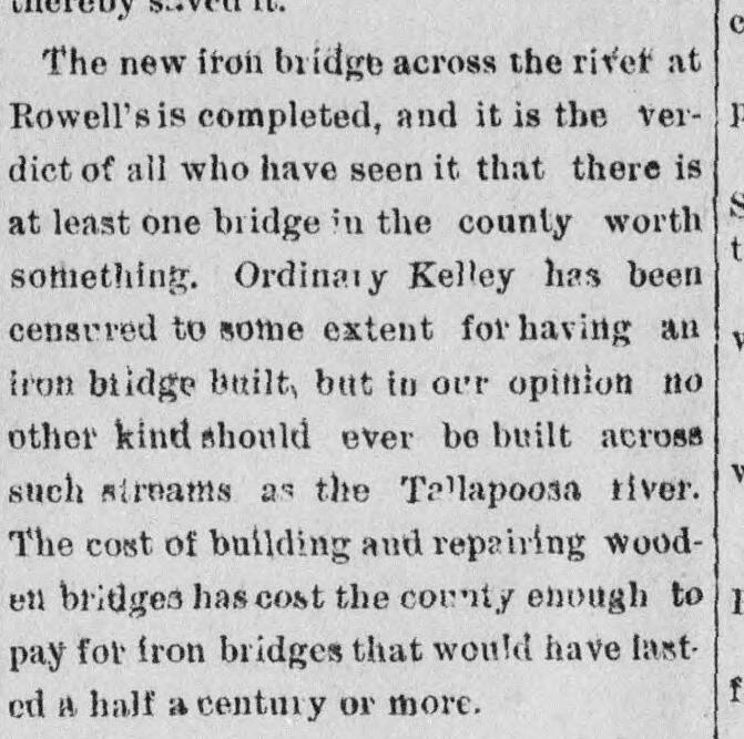
On August 3, the Banner-Messenger announced that the bridge was complete and acknowledged criticism of Kelley for having an iron one built. The paper defended him: the accumulated expense of building and repairing wooden bridges, it argued, could have paid for iron structures lasting half a century or more. That was the newspaper’s case for spending, not an audited comparison or proof of how long this bridge survived. [2]
Builders and a price
The contracting timetable had been advertised in advance. In the March 9 paper, Kelley asked for written plans, bids, sureties and a completion schedule. Proposals were due by noon April 3; if a satisfactory plan and bid arrived, he would let the work at noon April 4. He required at least five years of insurance, sound heart-pine or post-oak timber, and approaches that were not steep. This is the original solicitation, not the signed contract. [8]
The fuller construction account printed on August 10, reprinted from the Tallapoosa Journal, says the contract was indeed let on April 4, 1893, and construction was complete on July 28. The advertised timetable and the later report now support the same award date from opposite sides of the work. [1] [8]
The successful bidder was Alabama Bridge Company of Anniston. Other names describe different parts of the work: Carnegie rolled the iron sections; American Bridge and Iron Company of Roanoke, Virginia, made the bridge members; Brown brothers supplied timber. L. F. Bellinger served as the county’s engineer. [1]
The iron span measured 100 feet. Wooden approaches extended about 100 feet on the west and 35 feet on the east. The reported contract price was $2,529.50; a wooden alternative carrying a five-year guarantee would have cost $1,800. The question was how much more to spend at the beginning to avoid rebuilding after another flood. [1]
Leaving the river more room
The account pays close attention to the supports. Braced iron cylinders, narrower at their tops, were filled with hydraulic-cement concrete. Their foundations rested on gravel on the west and rock on the east, carried below the riverbed near the banks and outside the swift current. [1]
The writer contrasted that arrangement with the old stone-filled crib piers, which had obstructed part of the waterway. Those piers were dismantled and the stones removed below low-water level. Giving the river more room was part of the stated plan to resist the scouring that undermined bridges. The newspaper’s confidence that regular painting would make the structure last a lifetime remains a prediction, not its service record. [1]
A place to meet
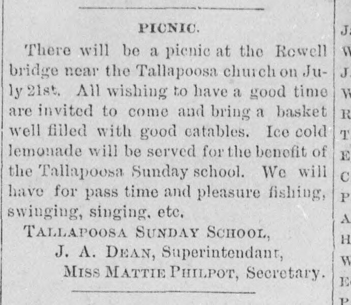
A year later, Rowell’s was a place to invite the neighbors. On July 12, 1894, the Banner-Messenger announced a picnic for July 21 at the Rowell bridge near Tallapoosa church. Guests were asked to bring food in baskets. The notice promised fishing, swinging and singing, with cold lemonade served for the benefit of the Tallapoosa Sunday school. [6]
J. A. Dean signed as superintendent and Mattie Philpot as secretary. Their invitation gives the bridge a life beyond the county’s construction argument: a recognizable place where a Sunday school planned to gather people. It is an advance notice; a report confirming the picnic, its attendance or its proceeds has not yet been found. [6]
That summer also brought a proposed road. In a notice dated July 26 and printed August 9, Kelley described a route crossing Green Creek, passing Ebenezer church before meeting the Buchanan road east of the iron bridge at the Rowell place. He announced that an order would be granted on August 20 if no good cause were shown against it. The notice establishes the proposal, not a completed road or a final approval. [7]
Following the name on a later map
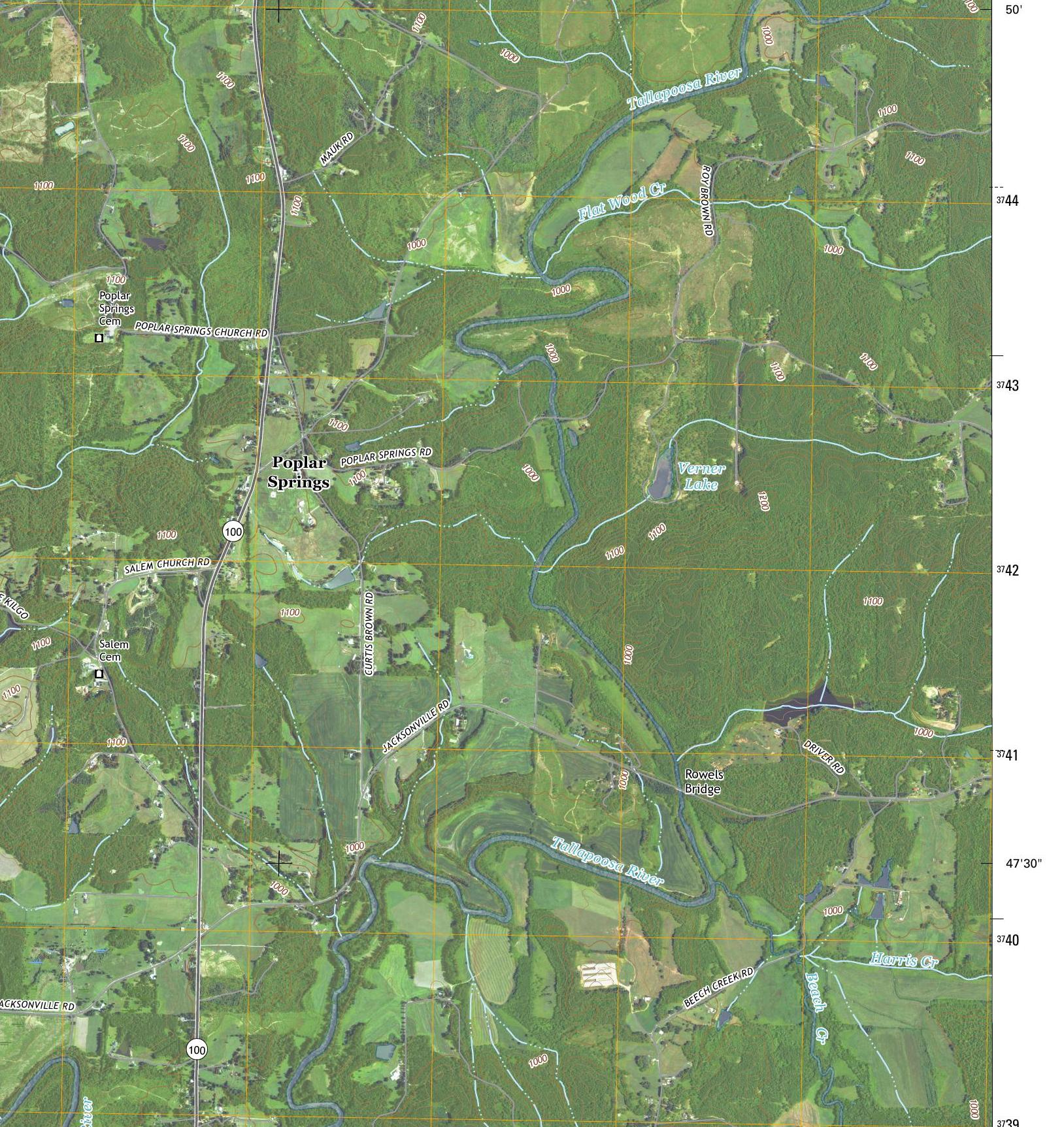
The 2017 USGS Tallapoosa North map labels Rowels Bridge beside Jacksonville Road, downstream from the separate Poplar Springs Road crossing. The spelling differs slightly from the newspaper’s Rowell’s, but the name and route together provide a useful location lead. [1] [3]
That correspondence is an inference, not proof that the 1893 ironwork survived there. It does not identify this span as the Virginia Bridge & Iron structure documented at Poplar Springs. The Bethlehem Church crossing in our family’s river story is another location farther upstream. Keeping those places separate lets each history develop without borrowing the other bridge’s dates or dimensions.
The 1893 writer finished by asking for a bridge over Beech Creek. Kelley reportedly intended to build one good bridge each year; the paper wanted that work to continue. One completed crossing had made the case for another. [1]
Sources and further reading
Research notes
Six original newspaper items and the 2017 map and collar were inspected. March’s loose-end report and August’s winter-destruction account do not establish a complete damage chronology. The original March solicitation independently establishes the advertised April contracting timetable; it is not a signed award. The fullest construction account is a Tallapoosa Journal reprint; its county/regional “first” claim is not independently established. The separate August 3 item does not prove independent reporting. The picnic is an invitation and the road citation is a conditional proposal. Contract, bids, acceptance, final payment, picnic follow-up, road order and later bridge replacement records remain to be found. The modern name/road correspondence is a location inference, not survival of the 1893 ironwork. Do not merge Rowell’s with HAER GA-50 at Poplar Springs, the Bethlehem family crossing or the unresolved Estes Mill crossing. No identified photograph of the 1893 span was found; no current condition, load limit or access is asserted.
- The Banner-Messenger, August 10, 1893, p. 2, “Haralson’s First Iron Bridge,” reprinted from the Tallapoosa Journal
Complete original column 2 inspected at high resolution. Reports Rowell’s location, April 4 award, July 28 completion, named builders, 100-foot iron span, 100/35-foot approaches and $2,529.50 price. The 16-foot-8-inch dimension is height, not width. Actual contract, acceptance and payment records not obtained. Regional priority, longevity and an annual building program are the writer’s claim, prediction and reported intention. Reprint attribution does not make two independent accounts. - The Banner-Messenger, August 3, 1893, p. 3, Local Leaflets
Original column 3 inspected. Announces Rowell’s iron bridge complete, acknowledges criticism of Kelley and argues for iron using cumulative wooden-bridge costs. Published before the August 10 reprint, but independent sourcing is not established. The half-century expectation is not verified service life. - U.S. Geological Survey, Tallapoosa North, GA–AL, 2017, 1:24,000 quadrangle
Original map and source collar inspected. Labels Rowels Bridge on Jacksonville Road separately from Poplar Springs Road. Imagery: NAIP, November 2015; roads: U.S. Census Bureau, 2015–2016; names: GNIS, 2016. The name/route comparison supports a historical location lead, not survival of the 1893 structure, a construction date for the mapped bridge, or present access. A separately inspected 1966 sheet leaves the crossing unnamed. - U.S. Geological Survey, topographic-map copyright and source guidance
Checked October 30, 2026. USGS maps are public domain subject to stated commercial-data exceptions. The inspected 2017 collar identifies Census roads and NAIP imagery; the older 2011 map uses commercially licensed road data and is not the reproduced image. - The Banner-Messenger, March 9, 1893, p. 5, “Rowell’s Bridge”
Original page and complete column 1 correspondence inspected. Signed Aunt Renia. Reports bridge ends loose and good school attendance on both sides; names Miss Sallie Harris and Mr. Thos. Hutcheson. Does not say pupils crossed the bridge. This contemporary damage description must be read alongside, not silently replaced by, the August retrospective account of winter destruction. - The Banner-Messenger, July 12, 1894, p. 3, “Picnic”
Original page and complete column 3 notice inspected. Announces July 21 at Rowell bridge near Tallapoosa church, with baskets, fishing, swinging, singing and lemonade benefiting Tallapoosa Sunday school. Signed J. A. Dean, superintendent, and Miss Mattie Philpot, secretary. An announcement is not evidence that the event occurred or a count of attendance or proceeds. - The Banner-Messenger, August 9, 1894, p. 3, second “Road Citation”
Original page and complete column 5 notice inspected. Signed Joe W. Kelley, Ordinary, July 26, 1894. Proposed route ends at Buchanan road east of the iron bridge at the Rowell bridge place. Conditional August 20 order is prospective; final order, road completion and identification with a modern alignment remain unproved. The old rock quarry mentioned in this proposed route is not identified with the quarry near the separate Bethlehem crossing. - The Banner-Messenger, March 9, 1893, p. 8, “Ordinary’s Office / Haralson County, Ga.”
Original page and complete column 2 solicitation inspected. Signed Joe W. Kelley. Calls for a bridge at Rowell place about six miles northwest of Buchanan; written plans, specifications, sureties and completion time by noon April 3, with conditional letting noon April 4. Specifies at least five years of insurance, rock piers, water span at least twenty feet above river bottom, sound heart pine or post oak and non-steep extensions. This is not the executed contract, a modern insurance policy or proof of an all-wood original design. Bed clearance is not the August account’s 16-foot-8-inch bridge height; specifications and reported completed supports are not proof of an unauthorized change.
Read another local story
 A steel bridge, a maker’s plate, and an uncertain birthdaySammy Fowler · HAER / Library of Congress
- The Road That Reached the River
 The Lake Haralson County Never GotUSGS · 1975 aerial photograph
Share a photo, memory or landmark
Daniel reviews contributions before anything appears publicly.
Know someone who would enjoy this? Pass it along.