HARALSON COUNTY · A STORY FROM OUR RIVER LAND
The Road That Reached the River
Before it became a question on an old map, this was somebody’s way to school.
My father-in-law remembers riding a school bus across the Tallapoosa here, with Harold Mize behind the wheel. He remembers riding his bicycle across, too. Those memories give the old Bethlehem Church Road crossing something a map cannot: a place in an ordinary childhood.
Our search began with a practical question about the road leading to our land. On the south side, an old roadbed runs toward the bridge from the Kelley Loop direction. We wanted to understand where it went and how people had used it.
That question led us into county maps, recorded deeds and photographs taken from airplanes decades ago. The more we looked, the more the bridge became part of a larger story: families on both banks, a church, roads, and a countryside where people worked as well as lived.
A road on the map
One of the clearest clues is on a 1985 county highway map. It shows a road numbered 204 leading to the crossing, with a connection to road 203 on the Kelley Loop side. Bethlehem Church and Spearman Lake help place the route in the surrounding countryside. [1]
That same map helps keep two bridge stories apart. Farther downstream, Road 189 crosses near Poplar Springs, south of Munroe Mill Road. That is the crossing documented in the federal HAER GA-50 bridge photographs. Our crossing is farther north, near Bethlehem Church and Spearman Lake. The separate road numbers and map positions establish that these are different bridges. [1] [13]
On paper, the connection is easy to follow. Standing beside the river today, you have to supply some of the picture yourself.
A bicycle and a school bus
My father-in-law remembers more of it. He places the crossing’s closure roughly between 1975 and 1985. Those are family recollections, not dates or names independently confirmed in county records.
We haven’t pinned those memories to an exact year. But they give the search a human scale: a bicycle ride, a driver’s name, and a school bus making its rounds.
Today, the bridge is what makes you stop and look.
The crossing from above
A federal aerial photograph dated January 26, 1972 gives the memory a visible setting. A narrow, straight span crosses the river, and the road continues from its south end. We matched the place by the river bends, the church area and the adjoining roads. The photograph documents a span on that date; it does not tell us who was using it. [5]
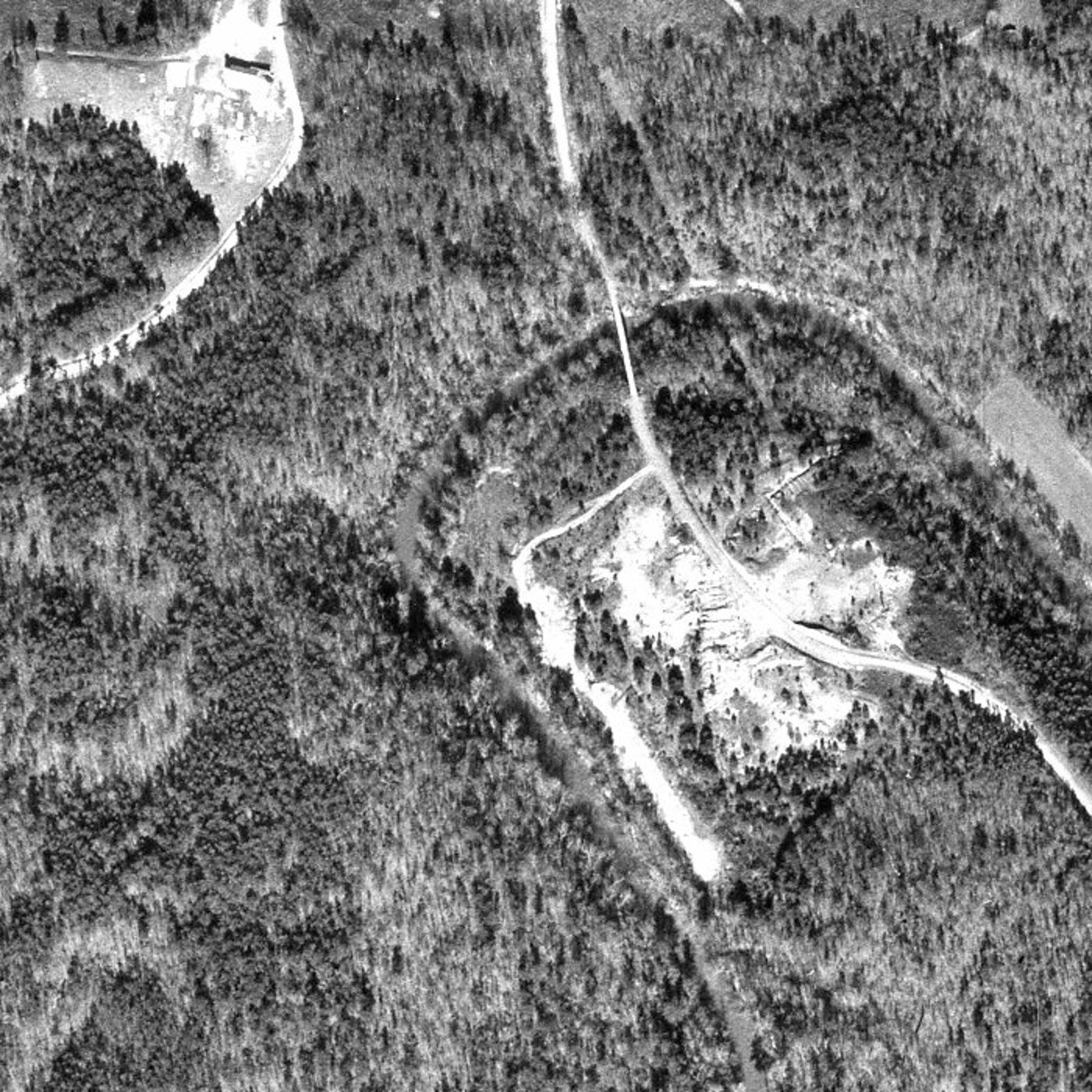
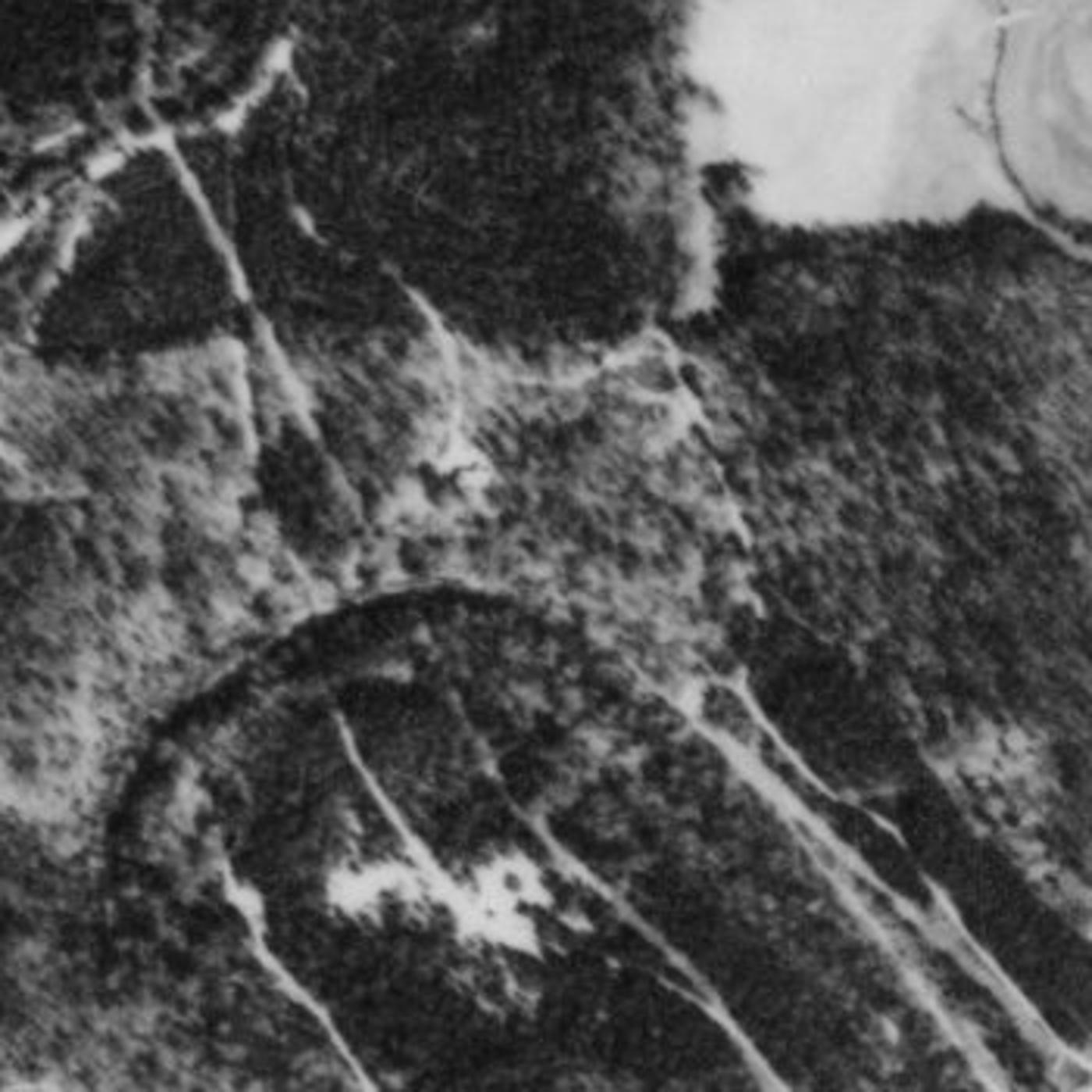
The February 29, 1988 photograph shows the same bends and an approach corridor, but its blur leaves the bridge’s condition unresolved. It cannot establish that vehicles could still cross, or prove that the deck had been removed. An approach remaining visible is different from a crossing remaining open. [6]
Compare the 1988 crossing detail
Land on both sides
The land records tell another part of the story. A deed recorded in 1993 describes an older tract on both sides of the Tallapoosa, including 18 acres south of the river, and refers back to a 1968 conveyance from Rufus S. Brown to Joseph A. Marcus. [2]
The language is plain: land lots, acreage, boundaries, the river. Read it with the place in front of you, though, and the river becomes more than a line in a legal description. You can see why a crossing mattered.
A working landscape, and a clearing we cannot yet explain
The 1972 photograph holds another question. Just south of the crossing, the ground is open and disturbed. Light patches and elongated shapes catch the eye. It is tempting to give them a name—a timber yard, a work area, a business—but the photograph does not resolve enough detail to tell us which, if any, is right.
A quarry rumor gave us another direction to look. On the 1966 USGS Tallapoosa North map, we found a place explicitly labeled “Quarry,” southwest of the bridge near Spearman Lake. Matching the surrounding bends and roads places that mapped quarry away from the bridge clearing. The rumor has a nearby geographical lead; it has not become an explanation for our ground. [7]
The old highway map also carries the name “Abernathys Mill” east of the crossing. In Georgia’s 1955 manufacturing directory, Abernathy Brothers of Buchanan appears as a sawmill and cotton gin. The 1960–61 directory lists Abernathy Bros. on Route 1 and reports an establishment date of 1882. Those records give us a business to investigate, although we have not yet proved that the directory entry and mapped mill refer to the same site. [8] [9]
For now, these are neighboring pieces of the landscape. We have not found a record placing that mill—or a quarry operation—on the clearing beside our bridge. But the names help us ask better questions of people who knew this stretch of river.
A mill name leads to people
Older newspapers give the Abernathy name a place in everyday county business. A tax notice published in the Haralson Banner on October 18, 1889 scheduled collector Joe W. Kelley at Abernathy’s mill that afternoon. The announced stop shows a mill serving as a recognizable meeting place, although it does not prove the collector made that particular visit. [10]
A decade later, the name comes with a father and son. On April 28, 1899, Buchanan’s Tribune reported that George Abernathy had come from Cherokee County, Alabama, and was working with his son G. W. Abernathy to erect a corn and wheat mill on the Tallapoosa a few miles north of Buchanan. A 1909–10 business directory then lists G. W. Abernathy under Buchanan with a gin and mill. [11] [12]
These records turn a map label into named people and specific work. They also leave a useful question: were the 1889 stop, the 1899 construction, the later directory business and the mill on the 1985 map all at the same place? We need deeds or a dated mill plan to connect them. None yet identifies the clearing beside our bridge.
What a flood could take
An older newspaper shows how much of that working life depended on the river behaving itself. The Haralson Banner of April 19, 1884 reported heavy damage to an Abernathy mill, gin and sawmill, including lost lumber, cotton seed, shop tools and sawlogs. A later note on the same page says the sawmill was nearly covered by water but had not washed down. A building could survive while the work inside and around it suffered. The report gives no first name or parcel that securely connects this operation to the later mill records. [14]
Six years later, the county’s published grand-jury presentments put the cost of keeping a crossing in service into unusually concrete terms. They recommended paying George Abernathy $125 to roof and weatherboard a Tallapoosa bridge on the Buchanan–Cedartown road, following plans filed with the Ordinary. He was to give an approved bond promising to carry out the work and rebuild the bridge if it washed away or was otherwise destroyed. This was a conditional recommendation, not a receipt for completed work. [15]
That 1890 bridge has not been linked to our steel crossing. But the records sharpen the search: there were particular businesses to protect, crossings to maintain and agreements about who would rebuild when the river took them.
The valley people studied for a lake
There was also a time when planners were considering a very different future for this valley.
In 1990, archaeologists surveyed approximately 4,000 acres for a proposed West Georgia reservoir. Across that study area, they recorded 242 archaeological sites and 22 historic structures. Those findings belong to the wider surveyed landscape; they do not establish what was on our particular campsite. [3]
Still, the survey adds something worth thinking about while you sit beside the water. This valley held enough traces of earlier lives to occupy a substantial research effort. And people were studying what a reservoir might change.
The reservoir proposal is part of the history around this stretch of river. So is the road. So are the families who knew the crossing when it was useful. We tell more of the wider reservoir story in The Lake Haralson County Never Got.
The part we are still looking for
What we haven’t found is a reliable account of how that use ended.
There was significant flooding in the Tallapoosa basin in March 1990, but that regional event does not establish what happened to this bridge. The remembered closure window is earlier, and neither aerial settles the date or cause. County road and bridge records may distinguish when traffic stopped from when any later damage or removal occurred. [4]
Until those turn up, that part of the story stays open.
A place to spend some time
For our family, learning the history has changed the way we see the campsite. The old roadbed deserves a second look. A name on a map becomes somebody worth learning about. A remembered bicycle ride makes the steel crossing feel a little less distant.
We hope guests find some of that same curiosity here.
You don’t need to know every former owner or every road number to enjoy an evening beside the Tallapoosa. But hearing someone remember a school bus coming this way, or pedaling across the bridge, gives you something to picture as the light fades over the river.
Our river stays have two different settings: Your Tallapoosa River Hideaway, with developed facilities and day-use or overnight options, and The Tallapoosa Hideaway Wilderness Retreat, our primitive 18-acre south-side retreat. They have separate Hipcamp listings, access arrangements, and availability. Meet the two river retreats and find their Hipcamp listings.
The Wilderness Retreat is closed to camping and leisure visits through January 10, 2027; later dates depend on its booking calendar. The old bridge is closed and is not an arrival route or a crossing for guests. Use only the directions provided for your booked site.
And perhaps someone reading this can help fill in the next page.
If you remember the crossing near Bethlehem Church Road and Kelley Loop, or have an old photograph showing the bridge or road in use, we would love to hear from you. Even an approximate year, tied to a school grade or a family event, could help. Share a memory, photograph, or source. We review contributions before publishing them.
For now, the river still runs past the old crossing.
And we’re glad to have a place beside it.
Sources and what remains unconfirmed
Published October 24, 2026. This story combines records reviewed during our research with family recollection. The map is evidence of a mapped route, not proof of present-day access or an easement.
- Haralson County, Georgia, 1985 highway map, Digital Library of Georgia / Coweta County Genealogical Society. The roadbed identification is our reading of the map alongside the location we know; modern road names are used for orientation.
- Haralson County Deed Book 340, pages 52–53, corrective survivorship deed dated December 20, 1993 and recorded December 21, 1993. Reviewed from record images. Describes 18 acres south of the river and 36 north, less a 10-acre exception; cites Rufus S. Brown to Joseph A. Marcus, August 10, 1968, Deed Book 123, page 235. GSCCCA records search (image access may require an account). These references do not establish a present right of way toward Kelley Loop.
- Thomas H. Gresham, Cultural Resources Survey of the Proposed West Georgia Regional Reservoir, 1990, report 1804. UGA Archaeology public abstract. Survey totals apply to the project area, not this campsite. No archaeological-site location on our land is claimed.
- U.S. Geological Survey, Floods of February and March 1990 in Alabama, Georgia, and Florida. Regional flood context only; it does not establish damage to this crossing. The bridge’s closure date, cause, construction date, and original name remain under investigation.
- Haralson County aerial photographs, 1972, ASCS Aerial Photography Division, frame 13143-172-067, dated January 26, 1972. University of Georgia Libraries, Map and Government Information Library, via DLG. The displayed crop is our visual location match, not a survey or a determination of access rights.
- Haralson County aerial photographs, 1988, U.S. Geological Survey, frame 71-GA316, dated February 29, 1988. Same repository. The scan does not establish whether the bridge was usable.
- USGS Tallapoosa North quadrangle, 1966, published 1967. The map labels a quarry southwest of the crossing; our comparison uses surrounding roads, lake and river bends. It does not identify the quarry operator, operating dates, or a connection to the bridge clearing.
- Georgia manufacturers, producers-processors, 1955, Haralson County listing and lumber-and-pulpwood listing: Abernathy Brothers / Abernathy Bros., Buchanan, sawmill and cotton gin. Georgia government publication via DLG.
- Georgia manufacturing directory, 1960–1961, printed page 129, Buchanan listing: Abernathy Bros., Route 1, sawmill, establishment date 1882. A reported business establishment date is not a verified construction date for a particular building.
- Haralson Banner, October 18, 1889, p. 1, Joe W. Kelley’s tax-collector notice, dated September 26. Original page image inspected through Georgia Historic Newspapers / Digital Library of Georgia. Announces an October 18 afternoon stop at Abernathy’s mill; it is a schedule, not evidence of a completed visit or a parcel identification.
- The Tribune, Buchanan, April 28, 1899, p. 5, Local News. Original page image inspected. George and G. W. Abernathy reported erecting a corn and wheat mill on the Tallapoosa north of Buchanan; completion, exact parcel and any link to our bridge clearing remain unproved.
- Young & Co.’s business and professional directory, 1909–10, printed p. 231, Buchanan (PDF p. 229). Original scanned page inspected: G. W. Abernathy, gin and mill. A town listing does not locate the operation’s land.
- HAER GA-50 historical data, County Road 189. Compared with the 1985 map’s separate Road 204 crossing. Original federal photographs show a different bridge with high sides and braces above the roadway; they must not be captioned as our family crossing.
- Haralson Banner, April 19, 1884, p. 3, “Haralson’s Flood” and accompanying notes. Original page image inspected. The damage list and closing sawmill note are parts of the same newspaper account, not independent corroboration. The account distinguishes damaged premises and lost contents from a sawmill being washed away. Its Abernathy references lack a first name and exact site.
- Haralson Banner, August 8, 1890, p. 1, “General Presentments for July Term 1890,” subsection “On Bridge—Tallapoosa River.” Original image inspected across the column break. The $125 payment, roofing, weatherboarding and rebuilding bond are recommended conditions. The underlying plans, approved bond, payment and completed work have not been located; the bridge’s modern location and George’s identity relative to the later father-and-son report remain unproved.
The school-bus and bicycle accounts are family recollections reported by Daniel Moss; the remembered driver and approximate 1975–1985 closure window have not been independently established. Expanded October 29, 2026 with the separate bridge identification, original Abernathy records, the 1884 flood report and the conditional 1890 bridge recommendation. HAER GA-50 belongs to Poplar Springs, not this crossing. Public references to Old Mize on Poplar Springs strongly match GA-50; the reservoir survey’s individual HS-15 sheet is still needed to complete that specific archival link. Neither the Mize name nor the newer Poplar Springs bridge’s 1982 construction establishes our bridge’s closure date.
Read another local story
- The Iron Bridge That Raised an Argument
 The Lake Haralson County Never GotUSGS · 1975 aerial photograph
- When the Tallapoosa Was Home
Share a photo, memory or landmark
Daniel reviews contributions before anything appears publicly.
Know someone who would enjoy this? Pass it along.