STORIES OF OUR PLACE · HARALSON COUNTY
The work that shaped our towns.
Factories, mines, railway sidings, vineyards and closed schools left different marks across Haralson County. The records help us understand what changed—and what we still need to find.
Haralson’s population is growing, but the county’s older centers of work do not all follow the same pattern. Our Census calculations put 79.2% of the county’s net population increase between the adjusted 2020 base and July 2025 outside incorporated cities. That finding raises questions about where people live today. Historical records raise a different set: who owned productive land, who financed a factory, who employed its workers, and what happened when the work stopped. [1]
The surviving evidence describes several local economies. Mill housing in Tallapoosa, a leased factory in Buchanan and mineral rights near Draketown represent different relationships between land, capital and labor. A countywide history needs to follow each one.
Tallapoosa: industrial expansion, idle plants and mill power
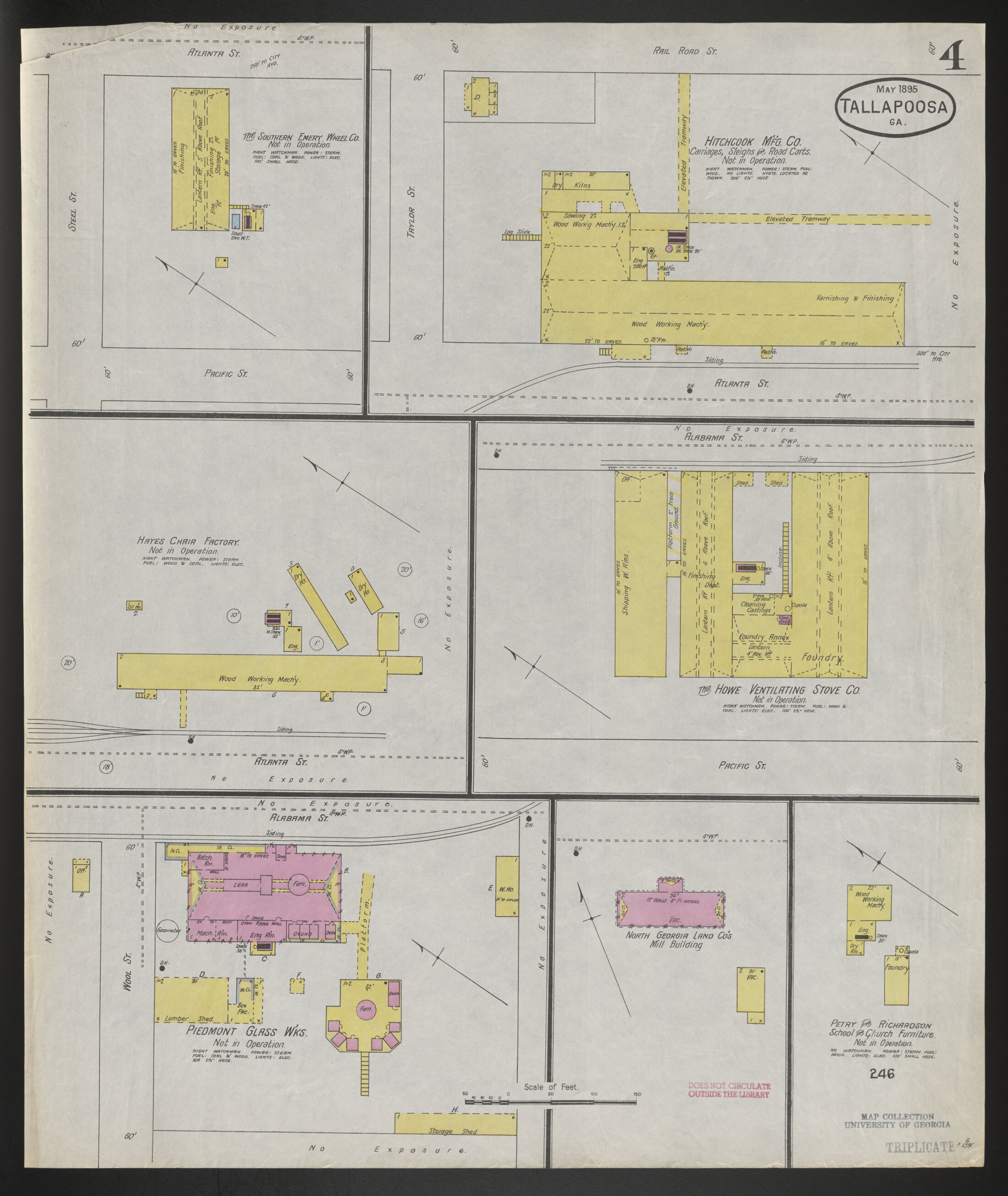
A May 1895 insurance map provides an unusually direct view of industrial contraction. Sheet 4 labels the Piedmont Glass Works, Southern Emery Wheel Company, Hitchcock Manufacturing Company and other plants as out of operation. Their buildings and railway connections were still worth mapping. The sheet records inactivity at that date; it does not establish the cause, the final liquidation dates or the fate of each worker. [2]
Later cotton manufacturing brought a different set of assets. The National Register history describes a 1908 mill with 30 double houses for operatives. Employer-provided shelter linked work and housing, although the leases and eviction practices have not been established. The same history cites a 1939 liquidation, followed by American Thread’s purchase in 1943 and production in 1944. Those changes make it important to identify the owner and year before describing how “the mill” operated. [3]
Labor conflict is documented more firmly. In a 1953 decision, the Fifth Circuit enforced National Labor Relations Board findings that American Thread instigated, authorized or encouraged assaults on union leafleters at Tallapoosa in August 1949, and ratified or condoned the attacks. The leafleters were striking workers from the company’s Dalton plant. Describing the incident as a Tallapoosa wildcat strike would put the workers in the wrong dispute. [4]
For the financial relationship, the Historical Society catalogs a 1923 work record alongside merchandise-credit books. Comparing names, payments and balances could reveal how employment and credit interacted. We have inspected the catalog, not those ledger pages; company scrip and compulsory shopping remain unproved. [5]
Buchanan: a community put capital into a factory
The Arrow shirt plant opened in 1947. PVH’s corporate history describes local veterans organizing investment in a factory building that Cluett, Peabody & Co. agreed to lease. That account makes the terms of the building investment central to the story: who supplied the money, what the lease promised and who carried the risk if production left. The underlying subscriptions and contract still need examination. [6] [7]
A federal notice adds a concrete wage question. In November 1950, the Buchanan operation received a learner-certificate authorization under rules permitting subminimum learner wages. It establishes an authorization; payroll is needed to establish its actual use. Our Buchanan factory feature follows the record, the surviving building identified by the Textile Trail, and the conflicting closure accounts. [8]
Bremen: several employers, and limits on worker mobility
Bremen’s manufacturing history involved several firms. In NLRB v. Sewell Manufacturing (1949), the court upheld findings concerning antiunion interrogation, coercion and surveillance before a 1945 shutdown. The opinion also discusses a non-recruiting understanding between employers. Its ruling was mixed: the court rejected the Board’s proof concerning three failures to rehire and removed their reinstatement and backpay provisions. That distinction belongs alongside the findings against the employer. [9]
Our Bremen history article connects the railroad junction and working streets to period records. Comparing the town’s industrial buildings with deeds and payroll would establish which firm controlled which part of the working landscape.
Draketown: ore, mineral rights and the haul to the railway
The state’s 1918 geological report identifies Georgia Pyrites Company as landowner and Arizona and Georgia Development Company as lessee at the Tallapoosa/Waldrop mine near Draketown. It distinguishes 327 acres owned outright from mineral rights covering about 397 acres. These are different interests in land, not competing estimates of one property. [10]
The report describes an active early period in 1881–1885, renewed work in 1916–1917, and a nine-mile haul to the railway. Its 7,450 tons of shipping ore is a cumulative figure, not a year’s peak output. Transport and processing therefore belong in any account of the mine’s economics. The final shutdown and the present condition of shafts and dumps remain unverified. This mine’s name must not be mistaken for a location in Tallapoosa city. [10]
A school photograph is captioned 1909, while a separate archive catalog lists a 1911 Draketown Baptist Institute commencement invitation. Those records provide a second way into the community’s history beyond the mineral deposit. [11]
Waco: the depot as a place of work
Georgia Archives’ circa-1913 photograph shows railroad workers gathered with a handcar at Waco’s depot. It records the people and equipment behind railway service. A 1906 gazetteer transcription describes Waco as a Southern Railway trading point. Neither record establishes that a single company owned its independent stores or controlled the entire town. [12] [13]
Freight accounts and railway valuation maps would identify which businesses depended on the depot. The county tax catalog supplies another starting point: Waco district 1426 appears with Felton in Book 28 for 1951. The historic population table uses that larger district geography; modern city counts use Waco’s municipal boundary. [14]
Felton: railway commerce, with the employer still to identify
The 1906 gazetteer transcription places Felton on the Central of Georgia railway and describes merchants and shipping facilities. A later volunteer history suggests lumbering, but the dominant company and its landholdings have not been verified. Calling Felton a company town would require more evidence. [13] [15]
Emory’s Pitts Theology Library preserves a Felton Methodist Church photograph dated 1950–1951. Its archive reference—MSS 028, Box 10, Folder 31—makes it a traceable community record. It does not identify an industrial site or establish why employment changed. [16]
Flatwoods: follow the school tract
Flatwoods appears in the county’s closed-school index. The Buchanan timeline places its consolidation, together with Tallapoosa East and Mount Vernon, into Buchanan High School in the 1930s as school buses widened the attendance area. The exact school parcel and consolidation vote are still missing from this research. [11] [17]
Finding that tract would turn a remembered place-name into a location that can be checked against school attendance, bus routes, land transfers and farm ownership. No verified Flatwoods mill ruin or dominant employer has yet been identified.
Budapest and Nitra: vineyards, families and a changing market
The Historical Society preserves accounts of the wine settlements, vineyard work and the Estavanko family, including an undated workers’ photograph and a Nitra rectory photograph captioned 1991. These are valuable leads to people, institutions and land use. The original land contracts, sales accounts and deeds are needed to establish how the ventures distributed costs and risk. [18]
For the later landscape, read what the proposed reservoir’s surveys recorded. That article keeps the project’s documented cancellation separate from questions about particular land purchases or relocations.
Steadman and the rural districts belong in the record
The volunteer community history preserves an undated Steadman store and school/church photograph and names a vineyard development company. The school index supplies further leads in Buncombe, Corinth and other settlements. Captions and retrospective accounts can start an investigation; they do not establish a complete business history. Steadman also appears as Stedman. [11] [15]
The 1940 Census provides countywide coverage at a different scale. Its table lists 1920, 1930 and 1940 populations for all 13 districts: Tallapoosa, Seventh, Mountain View, Little Creek, Buchanan, Buncombe, Bremen, Felton, Waco, Draketown, Berea, Steadman and Corinth. We have transcribed and reconciled those rows to the county total. Explore the complete district table. A district sharing a settlement’s name is not a count of that village alone. [19]
Open the local photograph collections
These links take you to the repositories’ photographs and original captions. Dates below follow the catalogs; undated pictures remain undated. Reproduction permission for these photographs has not been established for this site.
- Waco depot workers, circa 1913Georgia Archives · Vanishing Georgia · hrl005
- Piedmont Glass Works, circa 1890Georgia Archives · H. H. French photograph · hrl011
- Tallapoosa Cotton Mills, circa 1915Georgia Archives · Vanishing Georgia · hrl026
- Arrow workforce, 1959Historical Society timeline · photo appears beneath the 1947 entry
- Felton Methodist Church, 1950–1951Pitts Theology Library, Emory · MSS 028
- Draketown and rural school photographsHaralson GAGenWeb · check each caption’s date and identification
- Steadman store and school/churchHaralson GAGenWeb · undated · courtesy Christine Carter
- Vineyard workers and the Nitra rectoryHistorical Society · family photographs courtesy Joseph Conley
Sources and the next records to examine
This is documentary research. It includes no new field inspection or archive interview. The next original-record priorities are Tallapoosa’s 1923 work and credit books, Buchanan’s factory lease and closure records, and the Flatwoods school tract.
- Census Bureau, Vintage 2025 Georgia population estimates. County growth and county-portion calculations; see the linked population study for the method.
- Sanborn-Perris, Tallapoosa, May 1895, sheet 4. Primary map; five-sheet collection and reuse statement.
- North Tallapoosa Residential Historic District nomination. Later reconstruction, including housing and the 1939–1944 mill chronology. Its cited newspaper originals were not independently read.
- NLRB v. American Thread, 204 F.2d 169 (1953). Primary judicial opinion concerning the 1949 attacks.
- HCHS Archives, A008.001, MG1: merchandise credit, {1m.1}, 1917–1923 (Box 1 VF7) and 1923–1927 (Box 2 VF1); work records, {1m.2}, 1923 (Box 2 VF5). Shelf 3-B-4. Catalog only. Earlier credit-book dates predate the reported 1908 opening; verify the business identity on the original volumes.
- University of West Georgia, Buchanan Textile Heritage Trail. Later history and building identification.
- PVH Archives, Arrow’s Enterprise documentary (2021). Corporate retrospective.
- Federal Register, November 25, 1950, pp. 8091–8092. Learner-certificate notice.
- NLRB v. Sewell Manufacturing, 172 F.2d 459 (1949). Primary opinion; enforcement was modified.
- Georgia Geological Survey Bulletin 33 (1918), pp. 68–82. Tallapoosa/Waldrop mine; primary state report.
- Haralson GAGenWeb schools, a volunteer index and donated images; HCHS Draketown Institute invitation catalog, May 9, 1911, MG2 {2m.5}, Box 1 VF8.
- Georgia Archives / DLG, Waco depot workers, hrl005, circa 1913.
- Genealogy Trails, 1906 gazetteer transcription. Original volume not inspected.
- HCHS county tax records catalog, RG1 {1.1}, Book 28, 1951, shelf 1-A-3.
- Haralson GAGenWeb community histories. Retrospective accounts and contributed photographs.
- Emory, Felton Methodist Church photograph, 1950–1951. MSS 028, Box 10, Folder 31.
- HCHS Buchanan timeline, 1910–1959. Retrospective school-consolidation account and dated Arrow photograph.
- HCHS, Budapest and the wine colonies. Peggy Kimball’s 2004 account; contributed family photographs added in 2006.
- 1940 Census, Georgia, Table 4, printed p. 248. County and district counts for 1920, 1930 and 1940.