Carrollton history
The Insurance Man Who Left Us a Town
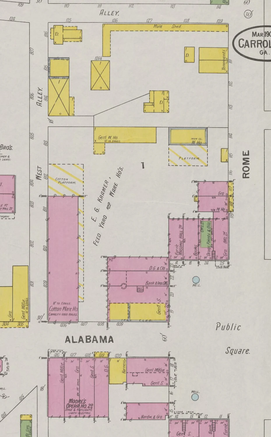
On a 1900 map of Carrollton, the mule shed gets its own label. So do the cotton platform, the blacksmith shop and the rooms above the stores. The map was made for fire insurance. More than a century later, it lets us look behind the shopfronts. [1]
In this story
A town with a working back yard
Start where Alabama Street meets the public square. On the northwest side, the March 1900 Sanborn map records E. G. Kramer’s feed yard and warehouses. A long cotton warehouse faces Alabama Street; the map gives its capacity as a thousand bales. Behind the neighboring shops are platforms, storage buildings and, along North Alley, the mule shed. [1]
The street fronts tell only part of the story. The same block contains a bank and insurance office, books, drugs, groceries, and paints and oils. Upstairs, the surveyors marked a Masonic hall. Across Alabama Street, Moore’s Opera House occupies a second floor above stores. Its stage and electric lighting are noted on the plan. Shopping, business, meetings and entertainment fitted into a small area, with animal handling and bulk storage behind them. [1]
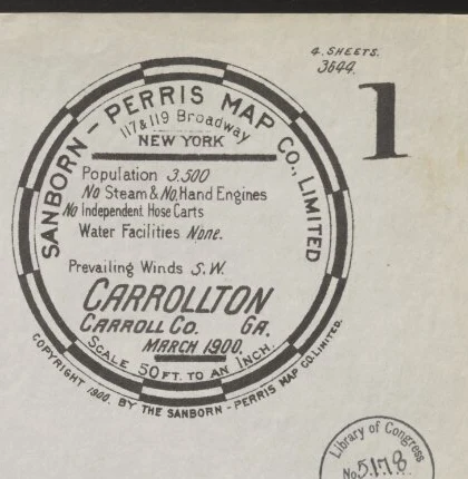
These details mattered to someone deciding what could burn, how a fire might spread and what stood nearby. The map’s colors distinguish construction materials, and its small marks record walls, windows and doors. A shop’s back wall or adjoining shed could be as important as its public entrance. Even the prevailing southwest wind was worth writing down. [1]
Benjamin Mandeville “Mann” Long later made another kind of working record. An insurance agent in Carrollton from 1917 into the 1960s, he photographed policyholders’ buildings and insurance claims. His surviving pictures belong to the University of West Georgia’s collections. They preserve ordinary places that somebody had a practical reason to examine. [2]
A family connection to fire protection
Long’s father was H. W. Long, a Carrollton mayor. The fire department’s own history places Mayor Long and the city council at the beginning of its organization in 1905. They bought equipment in March and recruited volunteers with posters and pamphlets in May. In October, A. P. Travis was elected the first chief. [2] [3]
The department added aluminum helmets, rubber coats and rubber boots in June 1908, followed by a horse team and fire wagon that September. When a motorized fire apparatus arrived in 1916, the horses and wagon remained available as a backup. Equipment, organization and people all had to be assembled. [3]
That progress makes a small note on the earlier insurance map especially striking. In March 1900, its surveyors recorded no steam or hand engines and two independent hose carts. They wrote “Water Facilities None,” although wells appear elsewhere on the sheets. The phrase describes the survey’s assessment of fire protection; it does not mean Carrollton had no water to drink. [1]
Before the fire
The worry reached readers through the newspaper, too. On March 23, 1920, the Carroll Free Press carried an advertisement from S. J. Boykin & Sons headed “Before the Fire.” It urged property owners to arrange coverage while their buildings were still standing. The seller was another local insurance agency; this was not Long’s advertisement. [4]
Beside the ad were ordinary newspaper offerings, including coffee and an automobile promotion. A warning about losing a business sat among invitations to buy things and get on with life. Insurance was part of that everyday commercial world. It became much less abstract when a building burned. [4]
What a warehouse fire left behind
Long’s collection includes photographs of the Bradley Street cotton-warehouse fire of February 18, 1937. In one, men stand among loose cotton, damaged bales and a hose stretched across the foreground. A partly surviving brick wall rises behind them. It is a record of the work after the flames, when the loss had become something people could walk through. [5]
The archive’s description, drawing on local news reports, gives four thousand bales destroyed, a loss of $300,000 and two people injured fighting the fire. Those figures come from the catalog’s account of the reporting; the photograph cannot establish them on its own. [5]
The 1900 plan and the 1937 picture belong to different moments. Together they show why cotton storage occupied so much space in the town’s working life, and why an insurer cared about buildings, their contents and their neighbors. The older map does not by itself identify the warehouse that burned thirty-seven years later. [1] [5]
The camera stayed for the changes
Long also recorded changes that were deliberate. Three photographs catalogued to 1958 show the removal of the landscaped island in Adamson Square. In the northwest-facing view, broken slabs and excavated soil lie beside the road. A truck and machinery stand near a tree, with shopfronts beyond. [6]
The archive identifies the island as the park around the Confederate monument and attributes its removal to a change in traffic arrangements. Companion views look east and northeast. The series records the square in transition, with the work still visible, rather than offering only a neat before-and-after pair. [6] [7] [8]
Put those photographs beside the old map and the familiar square becomes a place that people repeatedly rearranged to meet their needs. The map gives us storage yards, upstairs rooms and the spaces behind businesses. Long gives us walls, trees, vehicles and people at work. Neither record was made simply to tell today’s reader a story. [1] [6] [7] [8]
A building mattered to its owner before it mattered to a historian. Long’s camera preserved evidence of that ordinary care—and of how much a familiar place can change while keeping its name. [2]
Explore the original records
Open these records at the archive or family website for a closer look.
- Look through Mann Long’s photographs
UWG’s collection includes homes, businesses, street scenes and insurance-related photographs. Individual records supply their own dates and descriptions.
- The Bradley Street cotton-fire photograph
The original 1937 photograph discussed in this story, available to view at the archive.
- Adamson Square while the island was being removed
The northwest-facing photograph, catalogued to 1958; the source list links the other two views.
Sources and further reading
Research notes
The 1900 map predates Mann Long’s insurance career and is not his work. This story connects complementary records; it does not claim that he insured every photographed building, used this particular map, or handled the 1937 warehouse claim. No current parcel or business has been identified solely from historical street numbers. Long’s photographs are linked at the archive rather than reproduced because their reuse rights remain restricted. The Sanborn map is identified as public domain by the holding archive.
- Sanborn-Perris Map Company, Carrollton, Carroll Co., Ga., March 1900
Original sheets 1–3 visually inspected. Sheet 1: key and fire-protection note; sheet 2: east side of the square and warehouses; sheet 3: Kramer’s yard, cotton warehouse, mule shed, shops and Moore’s Opera House. University of Georgia Libraries Map Collection, via Digital Library of Georgia. - University of West Georgia, Long photograph collection
Collection description identifies Benjamin Mandeville “Mann” Long, his insurance career and the practical purposes of many photographs; also identifies his father as Mayor H. W. Long. Photographs remain under copyright. - Carrollton Fire Department, Our History
Department account of the 1905 organization, 1908 protective equipment and horse wagon, and 1916 motorized apparatus with horse-drawn backup. - Carroll Free Press, March 23, 1920, image 6
Original issue’s searchable text includes the S. J. Boykin & Sons insurance advertisement, coffee advertisement and automobile promotion. Page-image retrieval was blocked by archive verification; no facsimile is reproduced and no longer quotation relies on unverified OCR. - Benjamin M. Long, $300,000 cotton fire, February 18, 1937
Original photograph inspected. Warehouse location, bale count, loss estimate and injuries are attributed to the archive description, which cites local news reports. The underlying newspaper report and individual insurance claims were not inspected. - Benjamin M. Long, Adamson Square, 1958: northwest-facing view
Original photograph inspected. Archive identifies this as the first of three views of the park-island removal for traffic changes. - Benjamin M. Long, Adamson Square, 1958: east-facing view
Catalog identifies this as the second photograph in the sequence. Direction and date follow the archive. - Benjamin M. Long, Adamson Square, 1958: northeast-facing view
Catalog identifies this as the third photograph in the sequence. Direction and date follow the archive.
Read another local story
- When Carrollton’s Firemen Had to Pull the Wagon
 Southwire: How Carrollton learned to make wireU.S. patent drawing; no copyright notice in original scan. Reproduced under USPTO patent-publication guidance (source 9).
 The tracks that built West GeorgiaCram, 1883 · Library of Congress · public domain
Share a photo, memory or landmark
Daniel reviews contributions before anything appears publicly.
Know someone who would enjoy this? Pass it along.