Carroll County’s country roads
The Mail Had to Get Through
Oscar Payne’s mail wagon had a roof, a small enclosed compartment and tall, narrow wheels. In a photograph taken near Villa Rica around 1910, Payne sits at its open doorway with one foot down toward the muddy road. The horse waits in harness. The archive identifies the vehicle as U.S. Mail Wagon No. 2. [1]
In this story
Ready to leave Bowdon
Another photograph, made in Bowdon about two years later, catches the work before the journey. Five carriers stand against a brick wall among mailbags, bundles and boxes. According to the archive’s description, the mail had already been sorted and the men were preparing to leave the post office on their routes. [2]
Their names survive, too: P. C. Morris, George Downs, John Willis Hamil, Charlie Lovvorn and W. B. Rowell, from left to right. The picture gives them hats, faces and a day’s work to carry. It also gives later generations something unusually useful—a way to attach a family name to a working day. [2]
Town was the beginning of the journey. These carriers had to take the sorted mail farther. [2]
Bringing the post office closer
Before rural delivery, country residents generally collected their mail at a post office. The national rural free delivery experiment began in West Virginia in 1896 and became a permanent service in 1902. Its practical promise was simple: one carrier could make a round that spared many households a separate trip into town. [3]
West Georgia’s service arrived office by office. A Postal Service historical guide lists January 1, 1902, for Carrollton; February 1 for Temple; and November 1 for Villa Rica. It places Bremen and Buchanan on October 1, 1903, and Bowdon on November 1, 1904. The list is a research guide whose dates have not all been verified. [4] [5]
A route beginning at a town was a starting point. Reaching the surrounding households meant finding a way along the roads between them. The dates tell us when the guide places those beginnings; the later county map lets us follow the network out into the countryside. [4] [5] [6]
Roads, boxes and wheels
Rural carriers supplied their own transportation. They also sold stamps, handled money orders and registered letters. Passable roads were a condition of the service. So was a suitable place to leave the mail: from 1902, rural customers were required to provide approved boxes that protected it from weather. [3]
Payne’s photograph gives that road requirement a local setting. Under the wagon’s narrow wheels, the surface is muddy and marked by traffic. The road itself is part of the picture, as much as the carrier, the horse and the mail compartment. [1]
Transport changed as roads improved. By 1929, the Post Office Department described a nearly complete national shift from horse-drawn rural delivery to motorcars. The county’s surviving postal map belongs to that later era, after the horse-and-wagon photographs. [3] [6]
Twenty routes on one sheet
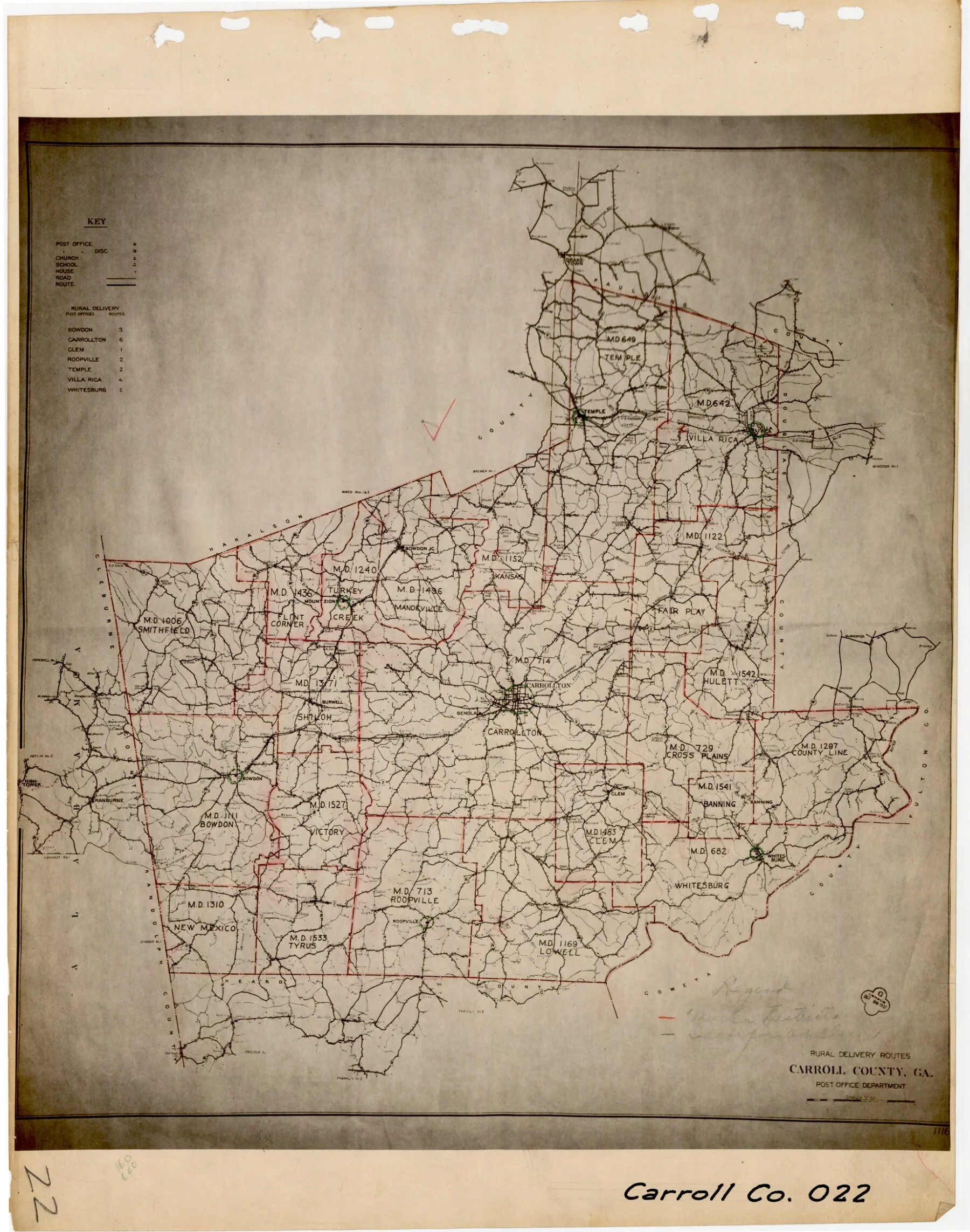
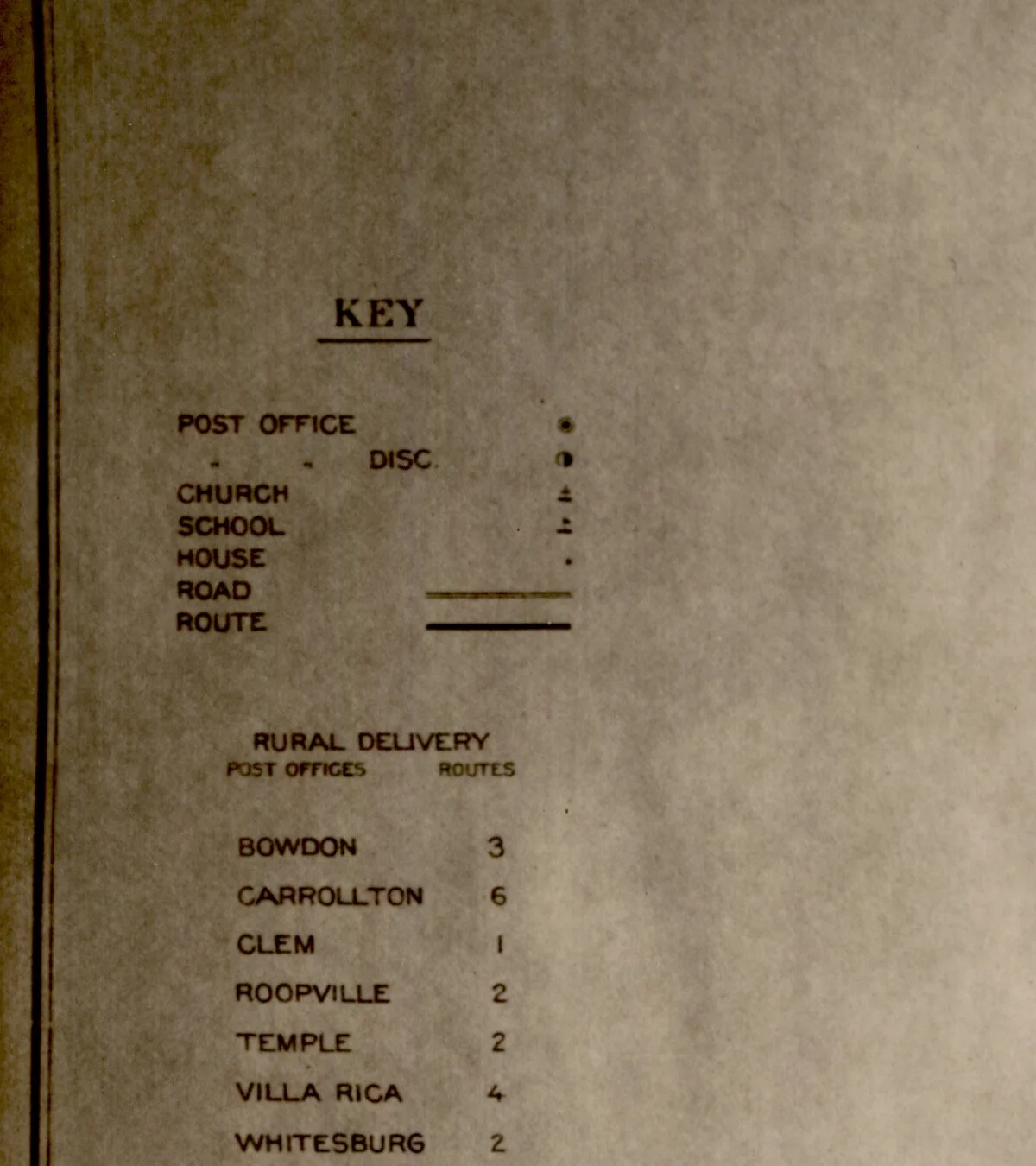
The surviving Carroll County postal map is undated. The University of Georgia places it approximately between 1930 and 1938. Its little table lists twenty rural routes from seven offices: six from Carrollton, four from Villa Rica, three from Bowdon, two each from Roopville, Temple and Whitesburg, and one from Clem. [6]
The table is only the beginning. A thin line means a road; a heavier line means a delivery route. Separate symbols mark houses, churches and schools. This is a map made to reach scattered people. Its many small marks preserve a different view of the county from a map concerned mainly with the quickest way between towns. [6]
Hand-added district names bring that countryside into focus. Turkey Creek, Shiloh, Victory, Cross Plains, Hulett, Lowell and New Mexico appear around the larger town names. A reader tracing family places can move from the familiar lettering of Carrollton or Bowdon into the smaller districts around them. [6]
The twenty routes belong to this later map, roughly two decades after the Bowdon photograph. Follow a heavy line away from a post office and the practical purpose becomes clear: joining scattered homes to a regular round. The small symbols along the way are the places that made the journey necessary. [6]
A carrier has a voice
One more record lets a reader move beyond the still pictures. In a 1981 oral history preserved by the University of West Georgia, Solon W. Ware discussed his work as a rural mail carrier. The interview index places that discussion at four minutes, forty-six seconds, and records that he began carrying mail in 1925. A later segment turns to his farm work. [7]
A carrier’s voice, five named faces and a map full of tiny houses: each brings the daily journey closer. Somebody’s mail had to reach the place they called home. [2] [6] [7]
Explore the original records
Open these records at the archive or family website for a closer look.
- See Oscar Payne beside his mail wagon
Georgia Archives photograph, near Villa Rica, about 1910. Open the image at the archive to examine the wagon and road.
- Meet Bowdon’s five photographed carriers
Georgia Archives photograph, about 1912, with the carriers named from left to right.
- Listen to Solon Ware’s account
Choose the 4:46 indexed segment for his rural-mail-carrier discussion. University of West Georgia’s Myron House oral history collection.
Sources and further reading
Research notes
The carrier photographs have approximate archive dates. The postal map is undated and catalogued approximately 1930–1938; it is not a reconstruction of Oscar Payne’s 1910 route. The Postal Service’s first-route list explicitly describes itself as an unverified guide compiled from earlier reports and Postal Bulletins. Solon Ware’s indexed interview is linked for listening; no quotation or detailed recollection has been inferred from its catalogue. The two Georgia Archives photographs are linked at the archive rather than republished here. The original postal map carries a No Copyright—United States rights statement.
- Georgia Archives, Oscar Payne and U.S. Mail Wagon No. 2, near Villa Rica, about 1910
Vanishing Georgia, CAR-188. Original photograph inspected. Payne’s identity, approximate date, location and wagon number follow the archive description; the visible pose, vehicle and muddy surface were checked against the image. - Georgia Archives, rural mail carriers at Bowdon, about 1912
Vanishing Georgia, CAR-19. Original photograph inspected. The archive identifies all five men and describes sorting completed before departure. - United States Postal Service historian, Rural Free Delivery
National context: 1896 experiment, 1902 permanence, carriers’ services and transportation, boxes, roads and the 1929 motorcar observation. These national developments do not establish a particular Carroll County carrier’s experience. - United States Postal Service, Georgia first rural-route dates through 1904
Postal Service historical compilation: Carrollton, Bowdon, Bremen and Buchanan on PDF p. 1; Temple on p. 3; Villa Rica on p. 4. The companion introduction explains the list’s verification limits. - United States Postal Service, introduction to First Rural Routes by State
Explains compilation from the 1901 Postmaster General’s report and Postal Bulletins through 1904; warns that all dates have not been verified. - United States Post Office Department, Rural Delivery Routes, Carroll County, Georgia
Original map and enlarged key inspected. Undated; UGA’s supplied range is approximately 1930–1938. Twenty routes are calculated from the seven entries in its table. Handwritten district annotations are distinct from the printed postal network. University of Georgia Libraries, Map and Government Information Library, as presented in the Digital Library of Georgia. - Myron House oral history collection, interview with Solon W. Ware, part 2
University of West Georgia. OHMS index inspected: rural-carrier discussion begins at 4:46; the index says he began in 1925; farm segment at 12:41. Interview title dates it December 15, 1981; the DLG record’s separate date field says December 5. No transcript was supplied, and no speech is quoted here.
Read another local story
 Bowdon College: A Small Town’s Big AmbitionPublic-domain U.S. publication, 1859; University of West Georgia catalogue scan.
 A school map from 1918. A different view of home.Georgia school survey · 1918
 Changing trains at BremenSanborn, 1900 · Library of Congress · public domain
Share a photo, memory or landmark
Daniel reviews contributions before anything appears publicly.
Know someone who would enjoy this? Pass it along.